PUBLICATIONS and PRESENTATIONS
. Tools for Simulating and Visualizing Petri Nets. 2018 AlaSim International Conference and Exposition. 2018 :88-109.
. Data Preparedness for Disasters, Hazards and Other Events . ESIP Winter Meeting. 2017 .
. Deep Learning for Multisensor Image Resolution Enhancement. In: GeoAI’17: 1st ACM SIGSPATIAL Workshop on Artificial Intelligence and Deep Learning for Geographic Knowledge Discovery. GeoAI’17: 1st ACM SIGSPATIAL Workshop on Artificial Intelligence and Deep Learning for Geographic Knowledge Discovery. Redondo Beach, CA USA: ACM; 2017.
. Deep Learning for Multisensor Image Resolution Enhancement. In: GeoAI’17: 1st ACM SIGSPATIAL Workshop on Artificial Intelligence and Deep Learning for Geographic Knowledge Discovery. GeoAI’17: 1st ACM SIGSPATIAL Workshop on Artificial Intelligence and Deep Learning for Geographic Knowledge Discovery. Redondo Beach, CA USA: ACM; 2017.
. Disaster Event-Based Data Collections with ArcGIS Online Data Processing . Esri Annual User's Conference. 2017 .
. Drowning in Data: Going Beyond Traditional Data Archival to Educate Data Users . American Geophysical Union 2017 Fall Meeting. 2017 .
. Enhancing Spatial Resolution of Remotely Sensed Imagery Using Deep Learning . AGU Fall Meeting, New Orleans, LA. 2017 .
. Enhancing Spatial Resolution of Remotely Sensed Imagery Using Deep Learning . AGU Fall Meeting, New Orleans, LA. 2017 .
. Event-Driven Virtual Collections for Community Solutions . ESIP Winter Meeting, Washington, D.C. 2017 .
. Lightning Imaging Sensor (LIS) on the International Space Station (ISS) Activation, Assessment and Operation in the First Six Months . International Space Station Research & Development (ISS&RD). 2017 .
. Supporting the Use of GPM-GV Field Campaign Data Beyond Project Scientists . American Geophysical Union 2017 Fall Meeting. 2017 .
. Using Satellite Lightning Data as a Hands-On Activity for a Broad Audience . American Geophysical Union 2017 Fall Meeting. 2017 .
. Making connections: Where STEM learning and Earth science data services meet. American Geophysical Union 2016 Fall Meeting. 2016 .
. Virtual Collections: An Earth Science Data Curation Service. American Geophysical Union 2016 Fall Meeting. 2016 .
. Virtual Collections: An Earth Science Data Curation Service. American Geophysical Union 2016 Fall Meeting. 2016 .
. Advances in Automated Services. In: IEEE Geoscience and Remote Sensing Symposium (IGARSS 2015). IEEE Geoscience and Remote Sensing Symposium (IGARSS 2015). Milan, Italy: IEEE; 2015.
. Data Systems for the HS3 Field Campaign. ESIP 2015 Winter Meeting [Internet]. 2015 . Available from: http://www.itsc.uah.edu/main/posters/data-system-hs3-field-campaign-agu-2014
. Linking from Observations to Data to Actionable Science in the Climate Data Initiative. In: IEEE Geoscience and Remote Sensing Symposium (IGARSS 2015). IEEE Geoscience and Remote Sensing Symposium (IGARSS 2015). Milan, Italy: IEEE; 2015.
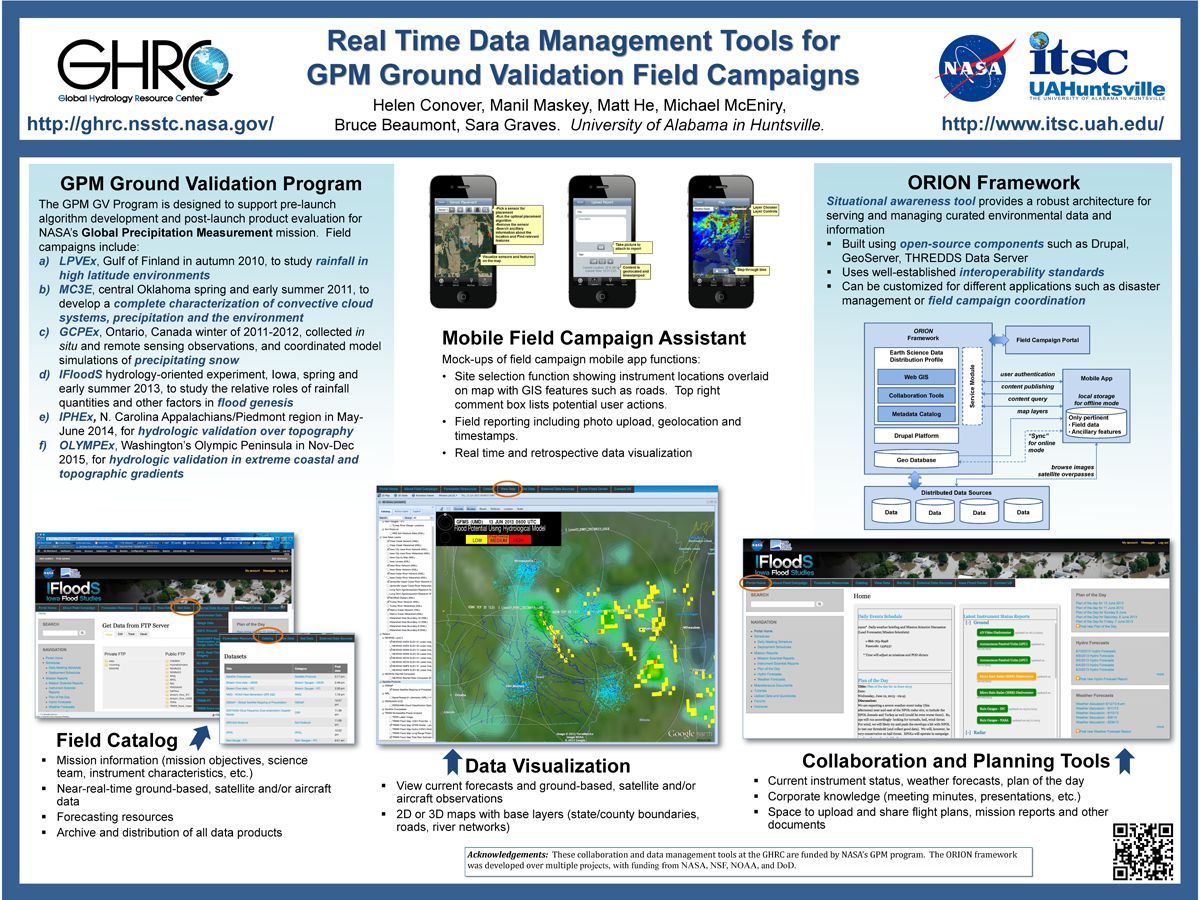
. Real Time Data Management Tools for GPM Ground Validation Field Campaigns. ESIP 2014 Winter Meeting [Internet]. 2014 . Available from: http://www.itsc.uah.edu/main/sites/default/files/GPMGV-Poster-ESIP-2014-01_sm.png
. Data Albums: A synthesis engine to support case study and climatology analysis. In: AGU. AGU. San Francisco, CA: AGU; 2013.
. Introducing Provenance Capture into a Legacy Data System. IEEE Transactions on Geoscience and Remote Sensing. 2013 ;51(11).
. ISO Lineage Metadata at the AMSR-E SIPS. ESIP Federation Winter Meeting 2013 [Internet]. 2013 . Available from: http://commons.esipfed.org/node/1037
. Provenance as a Guide to Understanding Science Data. IEEE International Geoscience and Remote Sensing Symposium. 2013 .
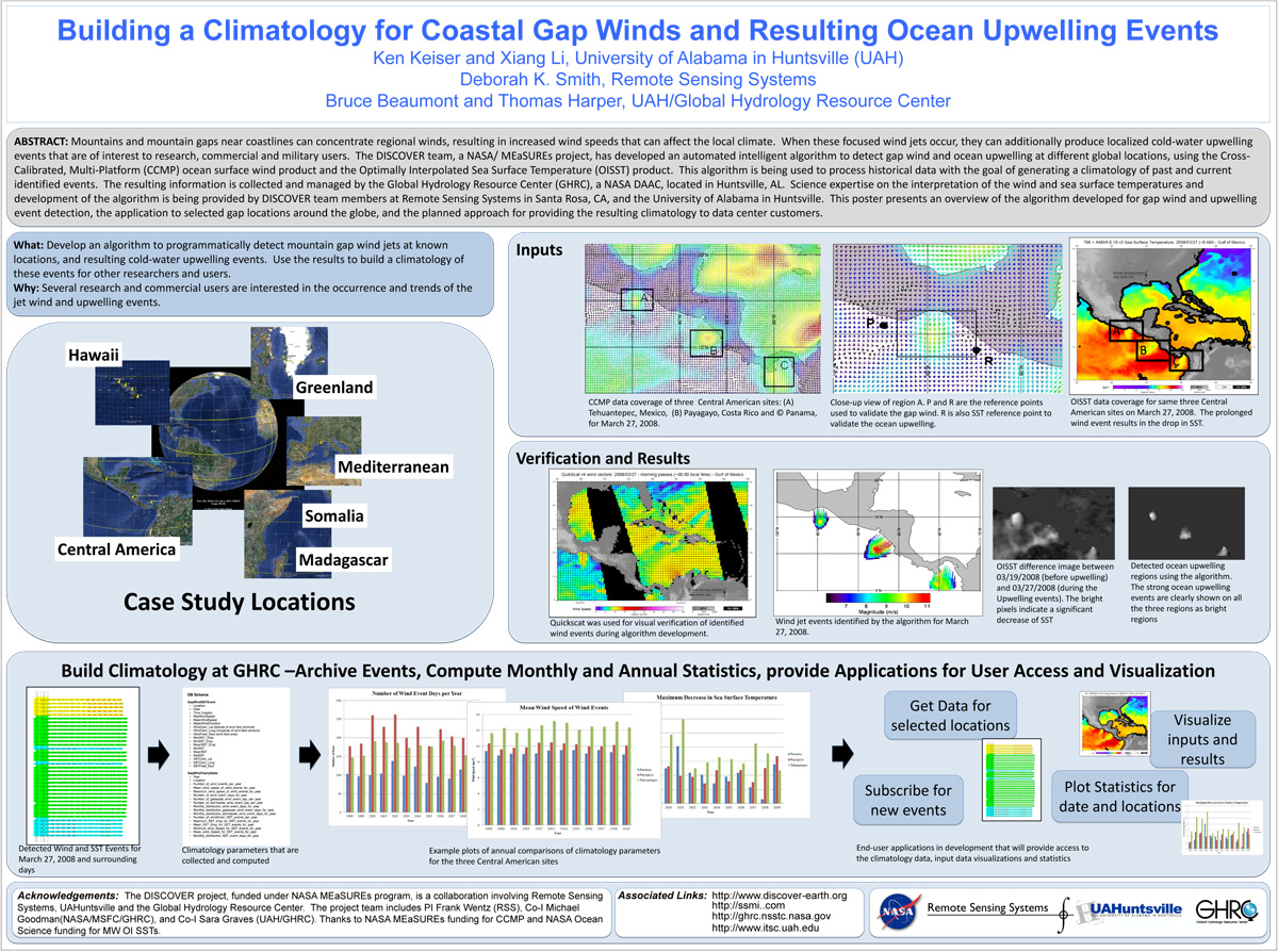
. Building a Climatology for Coastal Gap Winds and Resulting Ocean Upwelling Events. ESIP 2012 Winter Meeting [Internet]. 2012 . Available from: https://www.itsc.uah.edu/main/sites/default/files/ESIPmeeting2012_DISCOVER-GapWind-poster.jpg
