PUBLICATIONS and PRESENTATIONS
Found 51 results
Filters: First Letter Of Last Name is D [Clear All Filters]
. 2nd NASA Data Mining Workshop: Issues and Applications in Earth Science. Pasadena, CA: NASA; 2006. Available from: http://datamining.itsc.uah.edu/meeting06/docs/2nd_NASA_Data_Mining_D694F.pdf
. ADaM Services: Scientific Data Mining in the Service Oriented Architecture Paradigm. In: Data Mining Techniques in Grid Computing Environments. Data Mining Techniques in Grid Computing Environments. Wiley Publication; 2008.
. Advanced Information Management Services in SCOOP, an IOOS Testbed. In: Joint Assembly of the American Geophysical Union. Joint Assembly of the American Geophysical Union. Baltimore, MD; 2006.
. Application of EarlyLEAD to Study QPF Across the Mid-Atlantic. In: LEAD NSF Site Review. LEAD NSF Site Review. University of Illinois, Urbana Champaign; 2005.
. CHORDS: A pilot project for integrating real-time data into the EarthCube framework. In: EarthCube All Hands Meeting. EarthCube All Hands Meeting. Arlington, VA: EarthCube; 2015.
. CHORDS Building Block. In: EarthCube Tech Hands Meeting. EarthCube Tech Hands Meeting. La Jolla, CA: EarthCube; 2015.
. CHORDS Building Block. In: EarthCube Tech Hands Meeting. EarthCube Tech Hands Meeting. La Jolla, CA: EarthCube; 2015.
. CHORDS: Integrating Real-Time Geoscience Data into the EarthCube Framework. In: EarthCube All Hands Meeting. EarthCube All Hands Meeting. Arlington, VA: EarthCube; 2015.
. Collaboration Portals for NASA’s Airborne Field Campaigns (invited). American Geophysical Union. 2011 .
. Data Enabled Field Experiment Planning, Management, and Research using Cyberinfrastructure. Journal of Hydrometeorology [Internet]. 2015 ;16(3):1155-1170. Available from: http://journals.ametsoc.org/doi/pdf/10.1175/JHM-D-14-0163.1
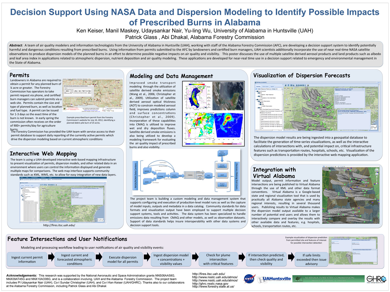
. Decision Support Using NASA Data and Dispersion Modeling to Identify Possible Impacts of Prescribed Burns in Alabama. ESIP Meeting 2012 [Internet]. 2012 . Available from: https://www.itsc.uah.edu/main/sites/default/files/Fires-for-ESIP-July-2012-v2.jpg
. Development of a Deep Learning Super-Resolution Generative Adversarial Network (SGAN) for Improving the Resolution of Global Precipitation Measurement (GPM) Dual-Frequency Precipitation Radar (DPR) Data. American Geophysical Union. 2019 .
. DISCOVER: A Service Oriented Approach to Managing Earth Science Data Across Distributed Project-specific Repositories. AGU 2008 Fall Meeting. 2008 .
. EarlyLEAD: A Non-Grid Application of LEAD Capability. In: LEAD NSF Site Review. LEAD NSF Site Review. University of Illinois, Urbana Champaign; 2005.
. ECITE and Beyond . NSF EarthCube All Hands Meeting. 2017 .
. A Fast Algorithm for Detecting Second Paths in Database Inference Analysis. Journal of Computer Security. 1995 ;Vol. 3:pp. 147-168.
An Integrated Approach for Accessing Multiple Datasets through LANCE. 2011 Fall Meeting AGU. 2011 .
An Integrated Approach for Accessing Multiple Datasets through LANCE. 2011 Fall Meeting AGU. 2011 .
. Intercomparison of candidate methods for mineral dust aerosol classification using MODIS infrared and visible channels. In: 17th International Conference on Geoinformatics. 17th International Conference on Geoinformatics. Fairfax, VA; 2009. Available from: http://ieeexplore.ieee.org/xpl/freeabs_all.jsp?arnumber=5292935
Linked Environment for Atmospheric Discovery (LEAD): A Cyberinfrastructure for Mesocyclone Meteorology Research and Education. AMS Annual Meeting; 20th International Conference on Interactive Information Processing Systems (IIPS) for Meteorology, Oceanography, and Hydrology. 2004 .
Linked Environment for Atmospheric Discovery (LEAD): A Cyberinfrastructure for Mesocyclone Meteorology Research and Education. AMS Annual Meeting; 20th International Conference on Interactive Information Processing Systems (IIPS) for Meteorology, Oceanography, and Hydrology. 2004 .
Linked Environments for Atmospheric Discovery (LEAD): Architecture, Technology Roadmap and Deployment Strategy. AMS Annual Meeting; 21st International Conference on Interactive Information Processing Systems (IIPS) for Meteorology, Oceanography, and Hydrology; 14th Symposium on Education. 2005 .
Linked Environments for Atmospheric Discovery (LEAD): Architecture, Technology Roadmap and Deployment Strategy. AMS Annual Meeting; 21st International Conference on Interactive Information Processing Systems (IIPS) for Meteorology, Oceanography, and Hydrology; 14th Symposium on Education. 2005 .
Mapping the biosphere: exploring species to understand the origin, organization and sustainability of biodiversity. Systematics and Biodiversity. 2012 ;10(1):1-20.
Mapping the biosphere: exploring species to understand the origin, organization and sustainability of biodiversity. Systematics and Biodiversity. 2012 ;10(1):1-20.
