PUBLICATIONS and PRESENTATIONS
. Integration of Multi-Regional Data resources for Decision Support in Mesoamerica. In: International Symposium on Remote Sensing of Environment 2007. International Symposium on Remote Sensing of Environment 2007. San Jose, Costa Rica; 2007.
. Intelligent Assimilation of Satelite Data into a Forecast Model Using Sensor Web Processes and Protocols. NASA Earth Science Technology Conference (ESTC 2008) [Internet]. 2008 . Available from: http://esto.nasa.gov/conferences/estc2008/papers/Conover_Helen_A1P2.pdf
. Intelligent Data Thinning Algorithm for Earth System Numerical Model Research and Application. 21st International Conference on Interactive Information Processing Systems (IIPS) for Meteorology, Oceanography, and Hydrology, 85th AMS Annual Meeting. 2005 .
. Intelligent Data Thinning Algorithms for Satellite Imagery. IEEE International Geoscience & Remote Sensing Symposium (IGARSS '08). 2008 .
. Interchange Technology for Applications to facilitate generic access to heterogeneous data formats. IEEE International Geoscience and Remote Sensing Symposium (IGARSS '02) and the 24th Canadian Symposium on Remote Sensing. 2002 .
. Intercomparison of candidate methods for mineral dust aerosol classification using MODIS infrared and visible channels. In: 17th International Conference on Geoinformatics. 17th International Conference on Geoinformatics. Fairfax, VA; 2009. Available from: http://ieeexplore.ieee.org/xpl/freeabs_all.jsp?arnumber=5292935
. The International Space Station Lightning Imaging Sensor: Performance, Applications, and Cross-Platform Science. In: American Geophysical Union Fall Meeting. American Geophysical Union Fall Meeting. Virtual: American Geophysical Union Fall Meeting; 2020.
. An Interoperable Environment for Geospatial Data. 2003 IEEE International Geoscience and Remote Sensing Symposium (IGARSS). 2003 .
. An Interoperable Framework for Mining and Analysis of Space Science Data (F-MASS). NASA AISRP Workshop. 2003 .
. An Interoperable Framework for Mining and Analysis of Space Science Data (F-MASS). Eos, Transactions, AGU. 2002 ;83.
. An Interpolated Counterpropagation Approach for Determining Target Spacecraft Attitude. In: The INNS World Congress on Neural Networks. The INNS World Congress on Neural Networks. San Diego, California; 1994.
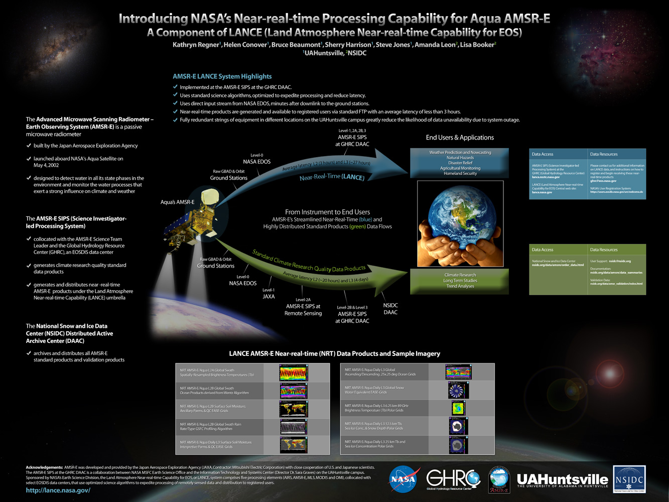
. Introducing LANCE, NASA’s Near-real-time Processing Capability for Aqua AMSR-E. In: American Geophysical Union. American Geophysical Union. San Francisco, CA; 2010.
. Introducing NASA's Near-real-time Processing Capability for Aqua AMSR-E . [Internet]. 2010 . Available from: http://www.itsc.uah.edu/main/sites/default/files/lance_poster.jpg
. Introducing Provenance Capture into a Legacy Data System. IEEE Transactions on Geoscience and Remote Sensing. 2013 ;51(11).
. Introducing Subset.Org: A Portal for Subsetting Applications and Related Tools. American Meteorological Society's (AMS) 19th International Conference on Interactive Information Processing Systems (IIPS) for Meteorology, Oceanography, and Hydrology. 2003 .
. Investigating Data Mining Techniques to Detect Dust Storms in MODIS Imagery. 32nd International Symposium on Remote Sensing of Environment. 2007 .
. ISO Lineage Metadata at the AMSR-E SIPS. ESIP Federation Winter Meeting 2013 [Internet]. 2013 . Available from: http://commons.esipfed.org/node/1037
. Key Provenance of Earth Science Observational Data Products. American Geophysical Union. 2011 .
. LANCE AMSR-E Status. College Park, MD: LANCE User Working Group Meeting; 2010.
. LANCE Processing at the AMSR-E SIPS. In: AMSR-E Science Team Meeting. AMSR-E Science Team Meeting. Huntsville, AL; 2010.
. Land, Atmosphere Near Real-time Capability for EOS (LANCE) AMSR2 Data System. American Geophysical Union 2016 Fall Meeting. 2016 .
. A Large Scale Sensor Network Simulation for Aircraft/Missile Detection/Tracking. In: Hyperspectral & Polarimetric Community Collaboration Workshop. Hyperspectral & Polarimetric Community Collaboration Workshop. Huntsville, AL; 2012. Available from: http://smapcenter.uah.edu/SMAP-CENTER/Conferences/HyperPolar2012/index.html
. Large-Scale Sensor Network Simulations for Air Defense Studies. In: Emerging and Enabling Technology Conference. Emerging and Enabling Technology Conference. Huntsville, AL; 2009.
The LEAD Science Portal Problem Solving Environment. 87th AMS Annual Meeting. 2007 .
. Lessons Learned in Applying Advanced Computing Technology at Boeing's Missiles and Space Division. In: Florida Artificial Intelligence Research Society (FLAIRS). Florida Artificial Intelligence Research Society (FLAIRS). ; 1993.
