PUBLICATIONS and PRESENTATIONS
Found 331 results
Filters: First Letter Of Last Name is G [Clear All Filters]
. Dayglow Removal from FUV Auroral Images. IEEE International Geoscience and Remote Sensing Symposium (IGARSS '04). 2004 .
. Dayglow Removal from FUV Auroral Images. IEEE International Geoscience and Remote Sensing Symposium (IGARSS '04). 2004 .
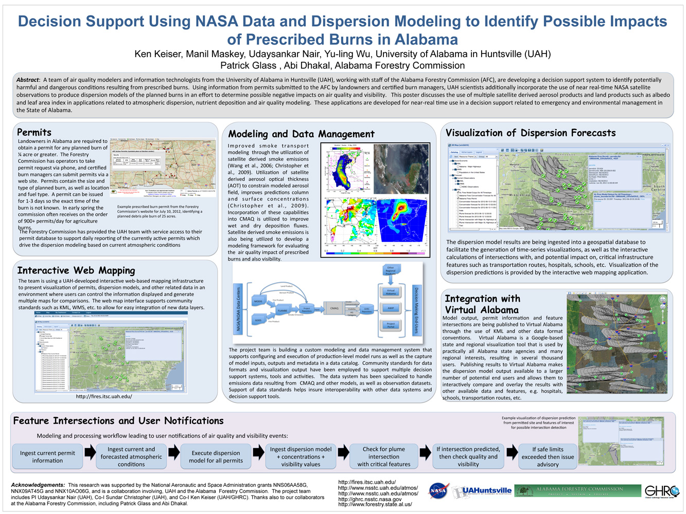
. Decision Support Using NASA Data and Dispersion Modeling to Identify Possible Impacts of Prescribed Burns in Alabama. ESIP Meeting 2012 [Internet]. 2012 . Available from: https://www.itsc.uah.edu/main/sites/default/files/Fires-for-ESIP-July-2012-v2.jpg
. Deep Learning for Multisensor Image Resolution Enhancement. In: GeoAI’17: 1st ACM SIGSPATIAL Workshop on Artificial Intelligence and Deep Learning for Geographic Knowledge Discovery. GeoAI’17: 1st ACM SIGSPATIAL Workshop on Artificial Intelligence and Deep Learning for Geographic Knowledge Discovery. Redondo Beach, CA USA: ACM; 2017.
. Deployable Suite of Data Mining Web Services for Online Science Data Repositories. 87th AMS Annual Meeting. 2007 .
. Detection of Cumulus Cloud Fields in Satellite Imagery. International Symposium on Optical Science, Engineering and Instrumentation (SPIE). 1999 .
. Disaster Response and Analysis Through Event-Driven Data Delivery (ED3) Technology – an Overview. SERVIR Summit. 2012 .
. Discovering and Accessing Data from the Federation of Earth Science Information Partners. Eos, Transactions, AGU. 2002 ;Vol. 83.
. DISCOVERing Online Data and Services. NASA Earth Science Technology Conference. 2004 .
. A discrete event simulation-based multi-objective reinforcement learning reward function for optimizing manufacturing material handling. 2019 Simulation Innovation Workshop. 2019 .
. A Distributed Knowledge Extraction Framework Based on Semantic Web Services. AISR NASA Investigator Workshop. 2008 .
. Distributed Services Technology for Earth Science Data Processing. American Meteorological Society's (AMS) 19th International Conference on Interactive Information Processing Systems (IIPS) for Meteorology, Oceanography, and Hydrology. 2003 .
. Distributed Technologies in a Data Pool. In: American Geophysical Union 2004 Fall Meeting. American Geophysical Union 2004 Fall Meeting. San Francisco, CA; 2004.
. Earth Science Data Mining and Knowledge Discovery Framework. SIAM International Conference on Data Mining. 2002 .
. Earth Science Markup Language. 81st American Meteorological Society (AMS) Annual Meeting, 17th Conference on Interactive Information and Processing Systems for Meteorology, Oceanography, and Hydrology. 2001 .
. Earth Science Markup Language: A Solution for Generic Access to Heterogeneous Data Sets. NASA Earth Science Technology Conference. 2001 .
. Earth Science Markup Language: A Solution to Address Data Format Heterogeneity Problems in Atmospheric Sciences. Bulletin of the American Meteorological Society. 2005 .
. Earth Science Markup Language: A Solution to the Earth Science Data Format Heterogeneity Problem. American Meteorological Society's (AMS) 19th International Conference on Interactive Information Processing Systems (IIPS) for Meteorology, Oceanography, and Hydrology. 2003 .
. Earth Science Markup Language: An Overview. Eos, Transactions, AGU. 2002 ;83.
. Earth Science Markup Language: An update. NASA Earth Science Technology Conference. 2002 .
. Earth Science Markup Language (ESML): a solution for scientific data-application interoperability problem. Computers & Geosciences [Internet]. 2004 ;30:117-124. Available from: http://www.sciencedirect.com/science/article/B6V7D-4BF5TY9-2/2/430d6854b74d0499f30ce80b57d51966
. Earth Science Mining Web Services. AGU 2008 Fall Meeting. 2008 .
. EarthCube’s Evolving Science Workbench. EarthCube All Hands Meeting. 2018 .
. ECITE: A Testbed for Assessment of Technology Interoperability and Integration with Architecture Components . American Geophysical Union 2016 Fall Meeting. 2016 .
. ECITE and Beyond . NSF EarthCube All Hands Meeting. 2017 .
