PUBLICATIONS and PRESENTATIONS
Found 331 results
Filters: First Letter Of Last Name is G [Clear All Filters]
. Framework for Mining and Analysis of Space Science Data. SIAM International Conference on Data Mining (2003). 2003 .
. Framework for Mining and Analysis of Space Science Data. SIAM International Conference on Data Mining (2003). 2003 .
. A Framework for Sensor Data and Product Processing. In: Workshop on Multi/Hyperspectral Technology and Applications. Workshop on Multi/Hyperspectral Technology and Applications. Redstone Arsenal, AL; 2002.
. GLIDER: A comprehensive software tool to visualize, analyze and mine satellite imagery. In: IEEE International Geoscience & Remote Sensing Symposium. IEEE International Geoscience & Remote Sensing Symposium. Cape Town, South Africa; 2009. Available from: http://wiki.esipfed.org/index.php/GLIDER:_A_comprehensive_software_tool_to_visualize,_analyze_and_mine_satellite_imagery
. GLIDER: A comprehensive software tool to visualize, analyze and mine satellite imagery. In: IEEE International Geoscience & Remote Sensing Symposium. IEEE International Geoscience & Remote Sensing Symposium. Cape Town, South Africa; 2009. Available from: http://wiki.esipfed.org/index.php/GLIDER:_A_comprehensive_software_tool_to_visualize,_analyze_and_mine_satellite_imagery
. GLIDER: A Platform for Remote Sensing Data Visualization/Fusion/Analysis. In: Hyperspectral & Polarimetric Community Collaboration Workshop. Hyperspectral & Polarimetric Community Collaboration Workshop. Huntsville, AL; 2012. Available from: http://smapcenter.uah.edu/SMAP-CENTER/Conferences/HyperPolar2012/index.html
. GLIDER: Application for Earth Science Data Mining and Visualization. In: Rocket City Geospatial & Alabama GIS Conference. Rocket City Geospatial & Alabama GIS Conference. Huntsville, AL; 2011.
. GLIDER: Earth Science Image Visualization and Analysis. 2010 [Internet]. 2010 . Available from: https://www.itsc.uah.edu/main/sites/default/files/glider_poster.jpg
. GLIDER: Free Tool Imagery Data Visualization, Analysis and Mining. In: American Geophysical Union. American Geophysical Union. San Francisco, CA; 2009. Available from: http://adsabs.harvard.edu/abs/2009AGUFMIN51C.07R
. Global Hydrology Resource Center: A Foundation for Research Using Earth Observation Data. In: 61st International Astronautical Congress. 61st International Astronautical Congress. Prague, Czech Republic; 2010.
. The Global Hydrology Resource Center Distributed Active Archive Center . 44th National Weather Association Annual Meeting. 2019 .
. Global Hydrology Resource Center (GHRC). In: EarthCube All Hands Meeting. EarthCube All Hands Meeting. Arlington, VA: EarthCube; 2015.
. The GPM Validation Network and Evaluation of Satellite-Based Retrievals of the Rain Drop Size Distribution . Atmosphere. 2020 ;11(9):1010.
. A Graph Theoretical Model for Partitioning and Allocation in a Distributed Computing System. 1981 .
. Grid-enabled Collaborative Research Applications. In: Internet2 Members Meeting, Advanced Applications Track Session. Internet2 Members Meeting, Advanced Applications Track Session. ; 2003.
. GRIP Collaboration Portal: Information Management for a Hurricane Field Campaign. In: American Geophysical Union. American Geophysical Union. ; 2010.
. GRIP Collaboration Portal: Information Management for a Hurricane Field Campaign. In: American Geophysical Union. American Geophysical Union. ; 2010.
. Ground-based Radar Validation Networks for GPM satellite products. In: American Geophysical Union Fall Meeting. American Geophysical Union Fall Meeting. Virtual: American Geophysical Union Fall Meeting; 2020.
. Heterogeneity and Evolution in Earth Science Data Systems and Services. In: Second New DISS Meeting. Second New DISS Meeting. Washington, D.C.; 1999.
. HLA-based Distributed Hardware-in-the-Loop Simulations Using Grid Technology. In: Huntsville Simulation Conference. Huntsville Simulation Conference. Huntsville, AL; 2003.
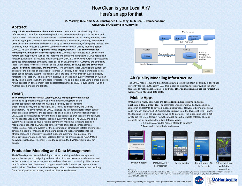
. How Clean is your Local Air? Here's an app for that. AGU 2011 [Internet]. 2011 . Available from: https://www.itsc.uah.edu/main/sites/default/files/agu2011_DEMAND-AQ-Poster.jpg
. A Hybrid Object-based/Pixel-based Classification Approach to Detect Geophysical Phenomena. In: Second NASA Data Mining Workshop: Issues and Applications in Earth Science. Second NASA Data Mining Workshop: Issues and Applications in Earth Science. Pasadena, CA; 2006.
. Image Segmentation Using Association Rule Features. IEEE Transactions on Image Processing. 2002 ;vol. 11:pp. 558-567.
. Implementing GEOSS Goals in Mesoamerica through the SERVIR Project. In: Joint Assembly of the American Geophysical Union. Joint Assembly of the American Geophysical Union. Baltimore, MD; 2006.
. An Improved Data Reduction Tool in Support of the Real-Time Assimilation of NASA Satellite Data Streams. AMS Annual Meeting. 2008 .
