PUBLICATIONS and PRESENTATIONS
. Visualizing Earth Science Data for Environmental Monitoring and Decision Support in Mesoamerica: The SERVIR Project. In: 1st International Workshop on Geographic Hypermedia. 1st International Workshop on Geographic Hypermedia. Denver, CO; 2005.
. Applications Algorithms for Optical Data Processing. Nichols Research Corporation, NRC79-AAODP-002, CDRL A004, SECRET; 1979.
. Applying Advanced
Technologies for
GeoInt Solutions. Geo-Energy Summit. 2014 .
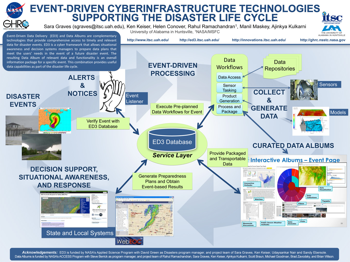
. Event-Driven Cyberinfrastructure Technologies Supporting the Disaster Lifecycle. AGU [Internet]. 2014 . Available from: http://www.itsc.uah.edu/main/sites/default/files/AGU-ED3-Eventdriven-poster.jpg
. ECITE: A Testbed for Assessment of Technology Interoperability and Integration with Architecture Components . American Geophysical Union 2016 Fall Meeting. 2016 .
. A Neural Network for Acquisition and Discrimination of Object Images. International Neural Network Society Annual Meeting. 1988 :p. 467.
. Critical BMD System and Sensor Concept Analysis Technical Assistance. EC Corporation, Final Report, Contract No. 5-31426, UAH-CAO-0001; 1986.
. Data Preparedness for Disasters, Hazards and Other Events . ESIP Winter Meeting. 2017 .
. An Interoperable Framework for Mining and Analysis of Space Science Data (F-MASS). NASA AISRP Workshop. 2003 .
. Collaboration Tools and Technologies for Scientific Field Campaigns. In: Internet2. Internet2. Atlanta, GA; 2010.
. An Interoperable Environment for Geospatial Data. 2003 IEEE International Geoscience and Remote Sensing Symposium (IGARSS). 2003 .
. Automated Data Delivery and Processing for Disaster Events. Earth Science Information Partners Federation 2013 Winter Meeting [Internet]. 2013 . Available from: http://www.itsc.uah.edu/main/posters/automated-data-delivery-and-processing-disaster-events
. Short Term Weather forecasting and Long Term Climate Predictions for Mesoamerica. In: Joint Assembly of the American Geophysical Union. Joint Assembly of the American Geophysical Union. Fort Lauderdale, FL; 2008.
. A Graph Theoretical Model for Partitioning and Allocation in a Distributed Computing System. 1981 .
. The Effects of Data Storage Paradigms on Custom Order Processing. In: ESDIS Prototype Review Session. ESDIS Prototype Review Session. Goddard Space Flight Center, Greenbelt, MD; 1997.
. Considerations for Semantic e-Science. In: American Geophysical Union. American Geophysical Union. San Francisco, CA; 2009. Available from: http://adsabs.harvard.edu/abs/2009AGUFMIN51B1043G
. The U.S. Global Change Data and Information Management Program Plan. a report by the Committee on Earth and Environmental Sciences, Interagency Working Group on Data Management for Global Change, Washington, D.C; 1992.
. EarthCube’s Evolving Science Workbench. EarthCube All Hands Meeting. 2018 .
. General introduction to GIS. (). Auburn University, AL: Ala. Coop. Ext. Sys; 2000.
. An Information Infrastructure for Coastal Models and Data. AGU 2007 Fall Meeting. 2007 .
. SERVIR: A Regional Monitoring and Decision Support System for Mesoamerica. In: Joint Assembly of the American Geophysical Union. Joint Assembly of the American Geophysical Union. Fort Lauderdale, FL; 2008.
. Implementing GEOSS Goals in Mesoamerica through the SERVIR Project. In: Joint Assembly of the American Geophysical Union. Joint Assembly of the American Geophysical Union. Baltimore, MD; 2006.
. SANDS - Sediment Analysis Network for Decision Support. In: American Geophysical Union. American Geophysical Union. San Francisco, CA; 2010.
. An Overview of the Data Holdings and Information Systems Technologies of the Global Hydrology Resource Center. American Geophysical Union, December 2008. 2008 .
. Integration of Multi-Regional Data resources for Decision Support in Mesoamerica. In: International Symposium on Remote Sensing of Environment 2007. International Symposium on Remote Sensing of Environment 2007. San Jose, Costa Rica; 2007.
