PUBLICATIONS and PRESENTATIONS
. Technology for the Transplant Professional: Making it work for you instead of against you. In: NATCO Symposium for Advanced Transplant Professionals. NATCO Symposium for Advanced Transplant Professionals. Miami, FL; 2012.
. A Collaborative Environment for the Northern Gulf Coastal Hazards Collaboratory. Northern Gulf Institute. 2011 .
. A Collaborative Multidisciplinary Environment for Coastal Science. American Geophysical Union Fall Meeting. 2011 .
. Data Casting for Integration of Applied Science Projects. In: ESIP Winter Meeting. ESIP Winter Meeting. Washington D.C.; 2011.
. GLIDER: Application for Earth Science Data Mining and Visualization. In: Rocket City Geospatial & Alabama GIS Conference. Rocket City Geospatial & Alabama GIS Conference. Huntsville, AL; 2011.
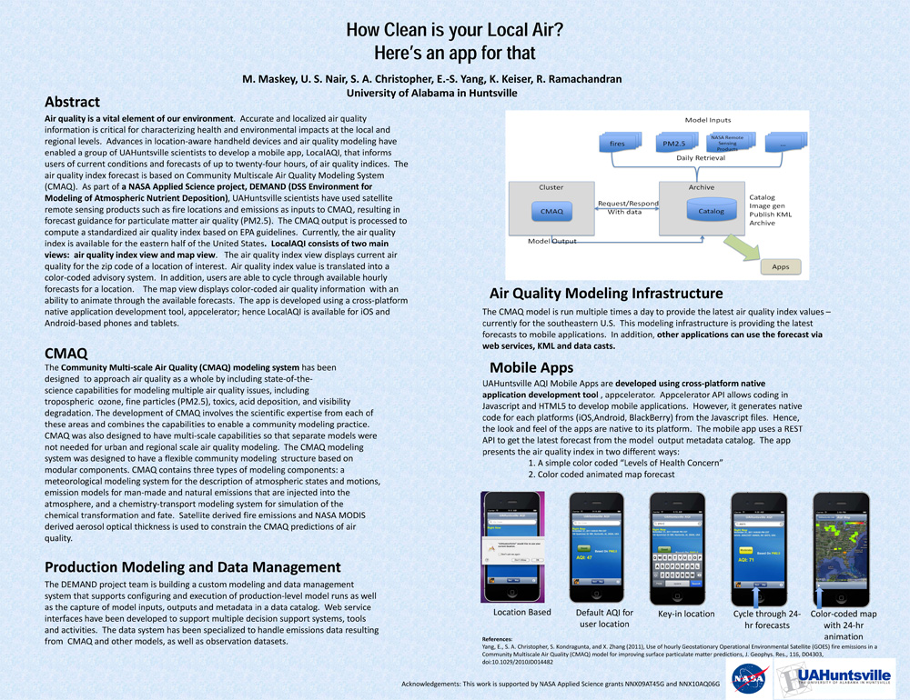
. How Clean is your Local Air? Here's an app for that. AGU 2011 [Internet]. 2011 . Available from: https://www.itsc.uah.edu/main/sites/default/files/agu2011_DEMAND-AQ-Poster.jpg
. OOSTethys / Oceans IE Service Registry Based on Catalog Service for Web. In: Geospatial Web Services: Advances in Information Interoperability. Geospatial Web Services: Advances in Information Interoperability. IGI Global; 2011.
. SCOOP Data Management: A Standards-based Distributed Information System for Coastal Data Management. In: Standards-Based Data and Information Systems for Earth Observation. Standards-Based Data and Information Systems for Earth Observation. Springer-Verlag; 2010. pp. 93-111. Available from: http://www.springerlink.com/content/h72m155753p3m2g6/
. Using Sensor Web Protocols for Environmental Data Acquisition and Management. Ecological Informatics. 2010 ;5(1):32-41.
. Extending a mass market tool to build collaborative portals in Geosciences. Cloud Computing and Collaborative Technologies in Geosciences. 2009 .
. GLIDER: A comprehensive software tool to visualize, analyze and mine satellite imagery. In: IEEE International Geoscience & Remote Sensing Symposium. IEEE International Geoscience & Remote Sensing Symposium. Cape Town, South Africa; 2009. Available from: http://wiki.esipfed.org/index.php/GLIDER:_A_comprehensive_software_tool_to_visualize,_analyze_and_mine_satellite_imagery
. Service Oriented Architecture for Data Mining at Data Centers and Computing Centers. Cloud Computing and Collaborative Technologies in Geosciences. 2009 .
. Visualize, Analyze and Mine Satellite Imagery Using a Single Tool. In: 17th International Conference on Geoinformatics. 17th International Conference on Geoinformatics. Fairfax, VA; 2009. Available from: http://ieeexplore.ieee.org/xpl/freeabs_all.jsp?arnumber=5292953
. ADaM Services: Scientific Data Mining in the Service Oriented Architecture Paradigm. In: Data Mining Techniques in Grid Computing Environments. Data Mining Techniques in Grid Computing Environments. Wiley Publication; 2008.
. Evolving Sensor Web Protocols for Sensor Data Management. Environmental Information Management 2008: Managing Sensor Data in Near Real Time. 2008 .
. Intelligent Assimilation of Satelite Data into a Forecast Model Using Sensor Web Processes and Protocols. NASA Earth Science Technology Conference (ESTC 2008) [Internet]. 2008 . Available from: http://esto.nasa.gov/conferences/estc2008/papers/Conover_Helen_A1P2.pdf
. Mining Scientific Data using Internet as the Computer. IEEE International Geoscience & Remote Sensing Symposium (IGARSS '08). 2008 .
. A Semantic Approach for Knowledge Discovery to Help Mitigate Habitat Loss in the Gulf of Mexico. In: American Geophysical Union (AGU) Fall meeting. American Geophysical Union (AGU) Fall meeting. San Francisco, CA; 2008.
. Deployable Suite of Data Mining Web Services for Online Science Data Repositories. 87th AMS Annual Meeting. 2007 .
. The Sensor Management for Applied Research Technologies (SMART) Project. NASA Science Technology Conference [Internet]. 2007 . Available from: http://esto.nasa.gov/conferences/nstc2007/papers/Goodman_Michael__A1P1_NSTC-07-0120.pdf
. Solution Service Composition for Analysis on Online Science Data. NASA Science Technology Conference [Internet]. 2007 . Available from: http://esto.nasa.gov/conferences/nstc2007/papers/Graves_Sara_A3P1_NSTC-07-0061.pdf
. Advanced Information Management Services in SCOOP, an IOOS Testbed. In: Joint Assembly of the American Geophysical Union. Joint Assembly of the American Geophysical Union. Baltimore, MD; 2006.
. Data Mining Web Services for Science Data Repositories. AGU Annual Meeting. 2006 .
. SCOOP Data Management: A Standards-based Distributed System for Coastal Data and Modeling. IEEE International Geoscience & Remote Sensing Symposium (IGARSS '06). 2006 ;1:317-320.
