PRODUCTS
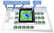
Several provenance collection and display tools have resulted from provenance research at ITSC in conjunction with the AMSR-E SIPS.The Earth science Library for Processing History (ELPH) is a provenance collection software library developed in Perl for integration...
ADaM is a data mining toolkit designed for use with scientific and image data. It includes pattern recognition, image processing, optimization, and association rule mining capabilities. ADaM does not contain grid projection, advanced subsetting, advanced statistical analysis...
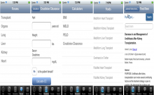
The mobile app "TransplantPro" allows transplant professionals to connect to other transplant professionals. Most commonly used transplant calculators are built into this app. Additionally, the app provides information about the recent publications and news on various...
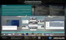
Airborne real time observations are a major component of NASA’s Earth Science research and satellite ground validation studies. For mission scientists, planning a research aircraft mission within the context of meeting the science objectives is a complex task because it...

GLIDER is a FREE tool to easily visualize, analyze and mine satellite imagery. GLIDER allows users to visualize and analyze satellite data in its native sensor view. User can enhance the image by applying different image processing algorithms on the data. GLIDER provides the...
