PUBLICATIONS and PRESENTATIONS
Found 158 results
Filters: First Letter Of Last Name is B [Clear All Filters]
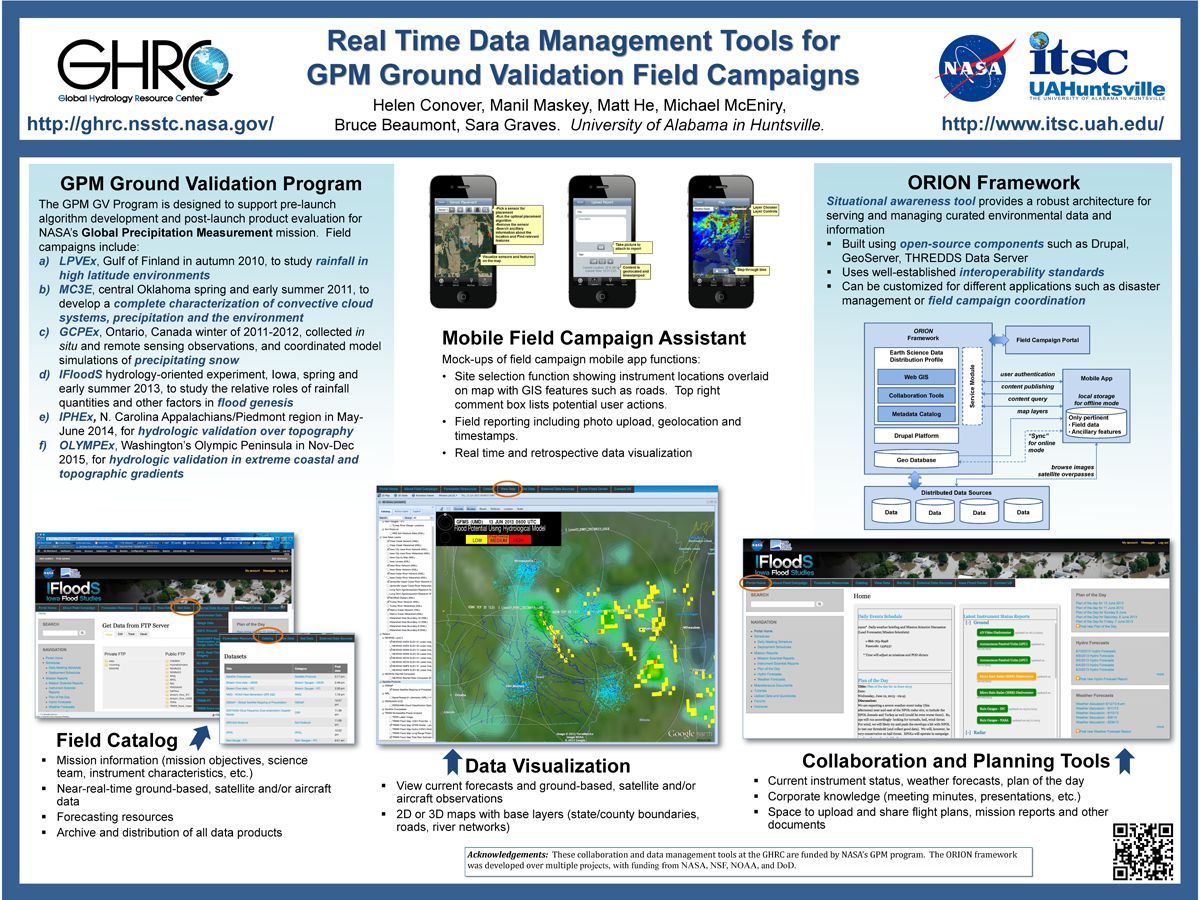
. Real Time Data Management Tools for GPM Ground Validation Field Campaigns. ESIP 2014 Winter Meeting [Internet]. 2014 . Available from: http://www.itsc.uah.edu/main/sites/default/files/GPMGV-Poster-ESIP-2014-01_sm.png
. Provenance Collection and Display Tools for the AMSR-E SIPS. In: NASA Earth Science Data Systems Working Groups (ESDSWG) Meeting. NASA Earth Science Data Systems Working Groups (ESDSWG) Meeting. Newport News, VA; 2011.
. Provenance Collection and Display for the AMSR-E SIPS. [Internet]. 2012 . Available from: https://www.itsc.uah.edu/sites/default/files/ESIPmeeting2012_ProvenancePoster_0.jpg
. Provenance as a Guide to Understanding Science Data. IEEE International Geoscience and Remote Sensing Symposium. 2013 .
. A Prototype for Earth Science Data on Demand. American Geophysical Union 2004 Fall Meeting. 2004 .
. Processing Direct Broadcast Data to Reduce Latency of Aqua AMSR-E Products. 2011 Fall Meeting AGU. 2011 .
. Processing Direct Broadcast Data to Reduce Latency of Aqua AMSR-E Products. In: AGU. AGU. San Francisco, CA; 2011.
. Precipitation Development and Electrification in Florida Thunderstorms During Convection and Precipitation/Electrification Project. Journal of Geophysical Research. 1996 .
. OOSTethys - Open Source Software for the Global Earth Observing Systems of Systems. In: American Geophysical Union. American Geophysical Union. San Francisco, CA; 2009. Available from: http://marinemetadata.org/community/teams/presence/presentations/agufm09-oost
. OOSTethys - Open Source Software for the Global Earth Observing Systems of Systems. In: American Geophysical Union. American Geophysical Union. San Francisco, CA; 2009. Available from: http://marinemetadata.org/community/teams/presence/presentations/agufm09-oost
. OOSTethys - Open Source Software for the Global Earth Observing Systems of Systems. In: American Geophysical Union. American Geophysical Union. San Francisco, CA; 2009. Available from: http://marinemetadata.org/community/teams/presence/presentations/agufm09-oost
. OOSTethys - Open Source Software for the Global Earth Observing Systems of Systems. In: American Geophysical Union. American Geophysical Union. San Francisco, CA; 2009. Available from: http://marinemetadata.org/community/teams/presence/presentations/agufm09-oost
. OOSTethys / Oceans IE Service Registry Based on Catalog Service for Web. In: Geospatial Web Services: Advances in Information Interoperability. Geospatial Web Services: Advances in Information Interoperability. IGI Global; 2011.
. A novel approach to detect regions of phenomena from NAM model outputs. In: 25th International Conference on Interactive Information Processing Systems (IIPS), 89th AMS Annual Meeting. 25th International Conference on Interactive Information Processing Systems (IIPS), 89th AMS Annual Meeting. Phoenix, AZ; 2009. Available from: http://ams.confex.com/ams/89annual/techprogram/paper_150718.htm
. New Tool for Satellite Image Analysis. 2011 ;92(11):1407.
The National Forum for Geosciences Information Technology (“FIGIT”). Joint Session on Cyberinfrastructure to support atmospheric and Oceanic Education: Examples and strategies, AMS Annual Meeting. 2005 .
. NASA Workshop on Issues in the Application of Data Mining to Scientific Data, Final Report. University of Alabama in Huntsville; 1999.
. Modeling Cyberattacks with Extended Petri Nets: Research Program Overview and Status Report. 2019 International Conference on Modeling, Simulation, and Visualization Methods. 2019 :27-33.
. Modeling Cyberattacks with Extended Petri Nets: Research Program Update. 2019 AlaSim Conference and Exhibition. 2019 .
. ML: What's Next for Earth Science?. NASA's Science Data Processing Workshop. 2002 .
. Mine Your Data: GLIDER brings data mining to the masses. [Internet]. 2012 . Available from: https://www.itsc.uah.edu/sites/default/files/esipmeeting2011_glider.jpg
Mapping the biosphere: exploring species to understand the origin, organization and sustainability of biodiversity. Systematics and Biodiversity. 2012 ;10(1):1-20.
Mapping the biosphere: exploring species to understand the origin, organization and sustainability of biodiversity. Systematics and Biodiversity. 2012 ;10(1):1-20.
Mapping the biosphere: exploring species to understand the origin, organization and sustainability of biodiversity. Systematics and Biodiversity. 2012 ;10(1):1-20.
Mapping the biosphere: exploring species to understand the origin, organization and sustainability of biodiversity. Systematics and Biodiversity. 2012 ;10(1):1-20.
