PUBLICATIONS and PRESENTATIONS
Found 146 results
Filters: First Letter Of Last Name is K [Clear All Filters]
. MIDAS: An Agent Based Data Transcoding Services Framework. Earth Science Technology Conference. 2004 .
. Metadata: The Golden Nuggets of Data Mining. In: First IEEE Metadata Conference. First IEEE Metadata Conference. Bethesda, Maryland; 1996.
. Meet Dizzy the Distometer: Creating a character and telling his story using ESRI Story Maps to increase use of Global Precipitation Measurement Ground Validation precipitation data . AMS 2019. 2019 .
Mapping the biosphere: exploring species to understand the origin, organization and sustainability of biodiversity. Systematics and Biodiversity. 2012 ;10(1):1-20.
The LEAD Science Portal Problem Solving Environment. 87th AMS Annual Meeting. 2007 .
The LEAD Science Portal Problem Solving Environment. 87th AMS Annual Meeting. 2007 .
. A Large Scale Sensor Network Simulation for Aircraft/Missile Detection/Tracking. In: Hyperspectral & Polarimetric Community Collaboration Workshop. Hyperspectral & Polarimetric Community Collaboration Workshop. Huntsville, AL; 2012. Available from: http://smapcenter.uah.edu/SMAP-CENTER/Conferences/HyperPolar2012/index.html
. Introducing Provenance Capture into a Legacy Data System. IEEE Transactions on Geoscience and Remote Sensing. 2013 ;51(11).
. An Interoperable Environment for Geospatial Data. 2003 IEEE International Geoscience and Remote Sensing Symposium (IGARSS). 2003 .
. The International Space Station Lightning Imaging Sensor: Performance, Applications, and Cross-Platform Science. In: American Geophysical Union Fall Meeting. American Geophysical Union Fall Meeting. Virtual: American Geophysical Union Fall Meeting; 2020.
. Integrated Geospatial Distribution Systems for Disaster Event Data . Geological Society of America Southeastern Conference. 2017 .
Instant Karma Status Update: Provenance at the AMSR-E SIPS. [Internet]. 2011 . Available from: https://www.itsc.uah.edu/sites/default/files/karma_poster.jpg
. Innovative Technologies for Sciences Data Processing. American Geophysical Union 2001 Spring Meeting. 2001 .
. An Information Infrastructure for Coastal Models and Data. AGU 2007 Fall Meeting. 2007 .
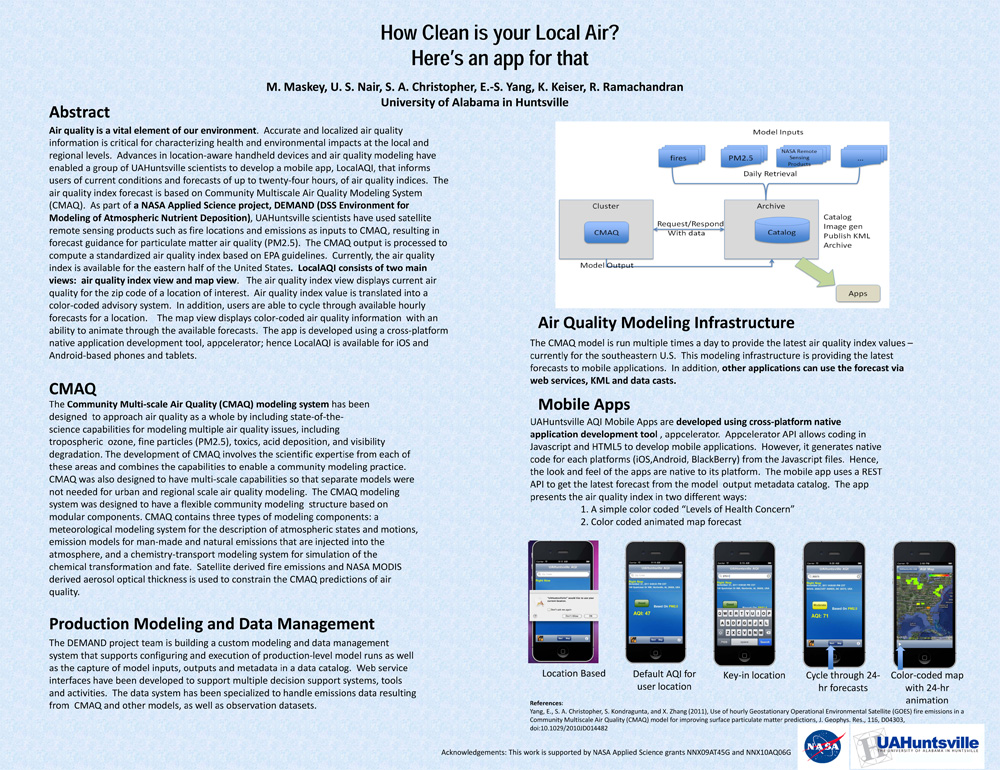
. How Clean is your Local Air? Here's an app for that. AGU 2011 [Internet]. 2011 . Available from: https://www.itsc.uah.edu/main/sites/default/files/agu2011_DEMAND-AQ-Poster.jpg
. Ground-based Radar Validation Networks for GPM satellite products. In: American Geophysical Union Fall Meeting. American Geophysical Union Fall Meeting. Virtual: American Geophysical Union Fall Meeting; 2020.
. GRIP Collaboration Portal: Information Management for a Hurricane Field Campaign. In: American Geophysical Union. American Geophysical Union. ; 2010.
. Global Hydrology Resource Center (GHRC). In: EarthCube All Hands Meeting. EarthCube All Hands Meeting. Arlington, VA: EarthCube; 2015.
. Global Hydrology Resource Center: A Foundation for Research Using Earth Observation Data. In: 61st International Astronautical Congress. 61st International Astronautical Congress. Prague, Czech Republic; 2010.
. GLIDER: Earth Science Image Visualization and Analysis. 2010 [Internet]. 2010 . Available from: https://www.itsc.uah.edu/main/sites/default/files/glider_poster.jpg
. A Framework for Sensor Data and Product Processing. In: Workshop on Multi/Hyperspectral Technology and Applications. Workshop on Multi/Hyperspectral Technology and Applications. Redstone Arsenal, AL; 2002.
. For Scientific Data Discovery: Why Can't the Archive be More Like the Web. Ninth International Conference on Scientific Database Management,. 1997 .
. Flexible Framework for Mining Meteorological Data. American Meteorological Society's (AMS) 19th International Conference on Interactive Information Processing Systems (IIPS) for Meteorology, Oceanography, and Hydrology. 2003 .
. Flexible Earth Science Data Mining Architecture. Fourth Workshop on Mining Scientific Datasets, Seventh ACM SigKDD International Conference on Knowledge Discovery and Data Mining. 2001 .
. Expanding the Role of an Earth Science Data System: The GHRC Innovations Lab. In: AGU. AGU. San Francisco, CA: AGU; 2013.
