PUBLICATIONS and PRESENTATIONS
Found 294 results
Filters: First Letter Of Last Name is R [Clear All Filters]
. Eureka Phenomena Discovery and Phenomena Mining System. American Meteorological Society (AMS) 13th International Conference on Interactive Information and Processing Systems (IIPS) for Meteorology, Oceanography and Hydrology. 1997 .
. Eureka Phenomena Discovery and Phenomena Mining System. American Meteorological Society (AMS) 13th International Conference on Interactive Information and Processing Systems (IIPS) for Meteorology, Oceanography and Hydrology. 1997 .
. Evaluation of Data Reduction Algorithms for Real-time assimilation and analysis. Weather Analysis and Forecasting [Internet]. 2010 . Available from: http://journals.ametsoc.org/doi/abs/10.1175/2010WAF2222296.1
. EVE: On-Board Process Planning and Execution. Earth Science Technology Conference. 2002 .
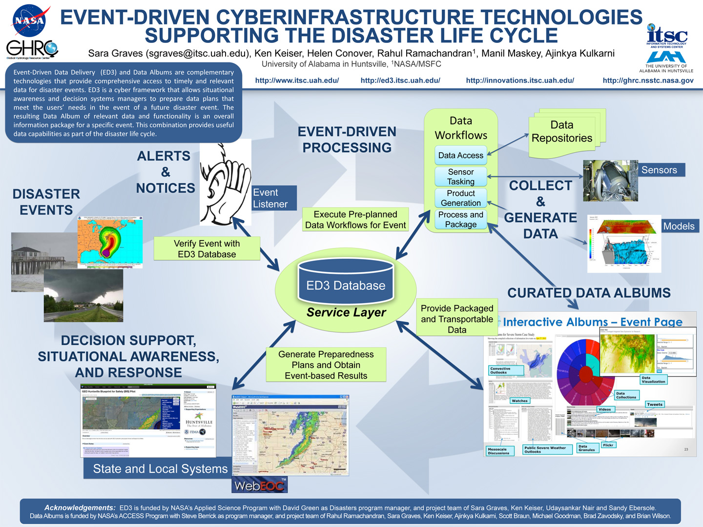
. Event-Driven Cyberinfrastructure Technologies Supporting the Disaster Lifecycle (at ESIP). ESIP 2015 Winter Meeting [Internet]. 2015 . Available from: http://www.itsc.uah.edu/main/sites/default/files/AGU-ED3-Eventdriven-poster.jpg
. Event-Driven Cyberinfrastructure Technologies Supporting the Disaster Lifecycle. AGU [Internet]. 2014 . Available from: http://www.itsc.uah.edu/main/sites/default/files/AGU-ED3-Eventdriven-poster.jpg
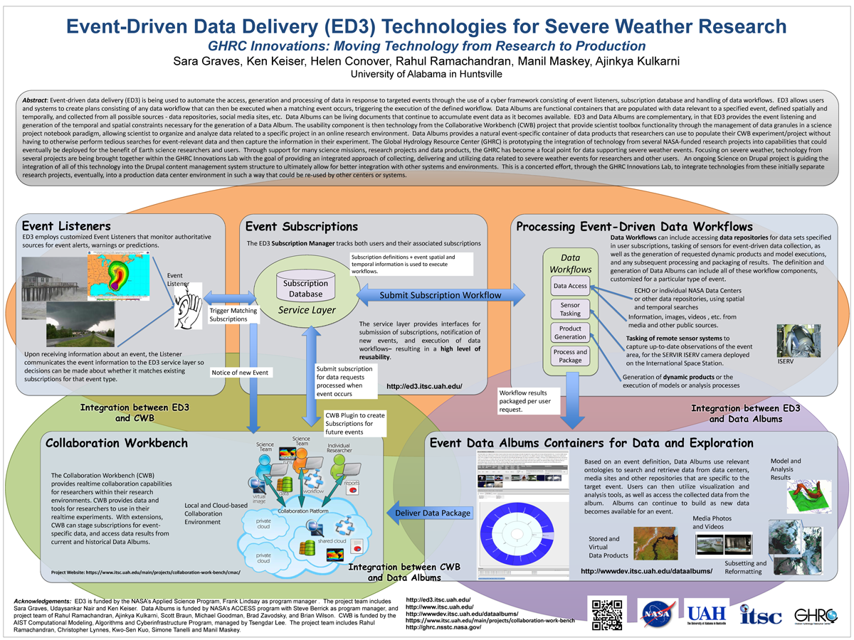
. Event-Driven Data Delivery (ED3) Technologies for Severe Weather Research, GHRC Innovations: Moving Technology from Research to Production. ESIP 2014 Winter Meeting [Internet]. 2014 . Available from: http://www.itsc.uah.edu/main/sites/default/files/ED3%2Bfor-ESIP-Jan-2014-v2_sm.png
. Evidence of Satellite Fragmentation by Orbital Debris. 76th Annual National Conference and Technical Career & Opportunity Fair, National Technical Association. 2004 .
. Evolving Sensor Web Protocols for Sensor Data Management. Environmental Information Management 2008: Managing Sensor Data in Near Real Time. 2008 .
. Expanding the Role of an Earth Science Data System: The GHRC Innovations Lab. In: AGU. AGU. San Francisco, CA: AGU; 2013.
. Extending a mass market tool to build collaborative portals in Geosciences. Cloud Computing and Collaborative Technologies in Geosciences. 2009 .
. Flexible Earth Science Data Mining Architecture. Fourth Workshop on Mining Scientific Datasets, Seventh ACM SigKDD International Conference on Knowledge Discovery and Data Mining. 2001 .
. Flexible Framework for Mining Meteorological Data. American Meteorological Society's (AMS) 19th International Conference on Interactive Information Processing Systems (IIPS) for Meteorology, Oceanography, and Hydrology. 2003 .
. Flexible Framework for Mining Meteorological Data. American Meteorological Society's (AMS) 19th International Conference on Interactive Information Processing Systems (IIPS) for Meteorology, Oceanography, and Hydrology. 2003 .
. Flexible Processing at the AMSR-E SIPS. In: IEEE International Geoscience and Remote Sensing Symposium (IGARSS '05). IEEE International Geoscience and Remote Sensing Symposium (IGARSS '05). Seoul, Korea; 2005.
. For Scientific Data Discovery: Why Can't the Archive be More Like the Web. Ninth International Conference on Scientific Database Management,. 1997 .
. For Scientific Data Discovery: Why Can't the Archive be More Like the Web. Ninth International Conference on Scientific Database Management,. 1997 .
. Framework for Mining and Analysis of Space Science Data. SIAM International Conference on Data Mining (2003). 2003 .
. Framework for Mining and Analysis of Space Science Data. SIAM International Conference on Data Mining (2003). 2003 .
. A Framework for Sensor Data and Product Processing. In: Workshop on Multi/Hyperspectral Technology and Applications. Workshop on Multi/Hyperspectral Technology and Applications. Redstone Arsenal, AL; 2002.
. GLIDER: A comprehensive software tool to visualize, analyze and mine satellite imagery. In: IEEE International Geoscience & Remote Sensing Symposium. IEEE International Geoscience & Remote Sensing Symposium. Cape Town, South Africa; 2009. Available from: http://wiki.esipfed.org/index.php/GLIDER:_A_comprehensive_software_tool_to_visualize,_analyze_and_mine_satellite_imagery
. GLIDER: Application for Earth Science Data Mining and Visualization. In: Rocket City Geospatial & Alabama GIS Conference. Rocket City Geospatial & Alabama GIS Conference. Huntsville, AL; 2011.
. GLIDER: Earth Science Image Visualization and Analysis. 2010 [Internet]. 2010 . Available from: https://www.itsc.uah.edu/main/sites/default/files/glider_poster.jpg
. GLIDER: Free Tool Imagery Data Visualization, Analysis and Mining. In: American Geophysical Union. American Geophysical Union. San Francisco, CA; 2009. Available from: http://adsabs.harvard.edu/abs/2009AGUFMIN51C.07R
. Global Hydrology Resource Center: A Foundation for Research Using Earth Observation Data. In: 61st International Astronautical Congress. 61st International Astronautical Congress. Prague, Czech Republic; 2010.
