PUBLICATIONS and PRESENTATIONS
. Using Satellite Lightning Data as a Hands-On Activity for a Broad Audience . American Geophysical Union 2017 Fall Meeting. 2017 .
. Supporting the Use of GPM-GV Field Campaign Data Beyond Project Scientists . American Geophysical Union 2017 Fall Meeting. 2017 .
. A New Way to Explore NASA Field Campaign Data. American Geophysical Union 2016 Fall Meeting. 2016 .
. Field Campaign Explorer: Simultaneous Data Exploration, Discovery, and Visualization. American Geophysical Union 2016 Fall Meeting. 2016 .
. Earth Science Data Education through Cooking Up Recipes. American Geophysical Union 2016 Fall Meeting. 2016 .
. Drowning in Data: Going Beyond Traditional Data Archival to Educate Data Users . American Geophysical Union 2017 Fall Meeting. 2017 .
. Meet Dizzy the Distometer: Creating a character and telling his story using ESRI Story Maps to increase use of Global Precipitation Measurement Ground Validation precipitation data . AMS 2019. 2019 .
. Lightning Imaging Sensor (LIS) on the International Space Station (ISS) Activation, Assessment and Operation in the First Six Months . International Space Station Research & Development (ISS&RD). 2017 .
. Dizzy the Disdrometer . AGU 2018. 2018 .
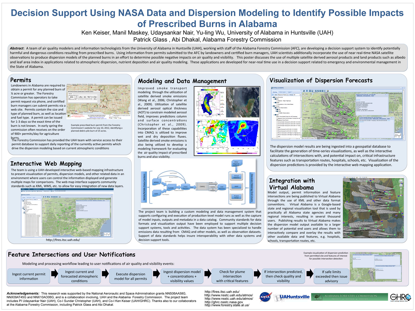
. Decision Support Using NASA Data and Dispersion Modeling to Identify Possible Impacts of Prescribed Burns in Alabama. ESIP Meeting 2012 [Internet]. 2012 . Available from: https://www.itsc.uah.edu/main/sites/default/files/Fires-for-ESIP-July-2012-v2.jpg
. Shortwave Direct Radiative Forcing of Biomass Burning Aerosols Estimated Using VIRS and CERES Data. Geophysical Research Letters. 2000 ;27:2197-2200.
Service-Oriented Environments in Research and Education for Dynamically Interacting with Mesoscale Weather. IEEE Computing in Science & Engineering. 2005 ;7:24-32.
Service-Oriented Environments in Research and Education for Dynamically Interacting with Mesoscale Weather. IEEE Computing in Science & Engineering. 2005 ;7:24-32.
Service-Oriented Environments in Research and Education for Dynamically Interacting with Mesoscale Weather. IEEE Computing in Science & Engineering. 2005 ;7:24-32.
Mapping the biosphere: exploring species to understand the origin, organization and sustainability of biodiversity. Systematics and Biodiversity. 2012 ;10(1):1-20.
Mapping the biosphere: exploring species to understand the origin, organization and sustainability of biodiversity. Systematics and Biodiversity. 2012 ;10(1):1-20.
Mapping the biosphere: exploring species to understand the origin, organization and sustainability of biodiversity. Systematics and Biodiversity. 2012 ;10(1):1-20.
Mapping the biosphere: exploring species to understand the origin, organization and sustainability of biodiversity. Systematics and Biodiversity. 2012 ;10(1):1-20.
. The GPM Validation Network and Evaluation of Satellite-Based Retrievals of the Rain Drop Size Distribution . Atmosphere. 2020 ;11(9):1010.
. Estimation of Surface and Top-of-Atmosphere Shortwave Irradiance in Biomass-Burning Regions during SCAR-B. Journal of Applied Meteorology. 2000 ;39:1742-1753.
. Estimation of Shortwave Direct Radiative Forcing of Biomass Burning Aerosols Using New Angular Models. Journal of Applied Meteorology. 2000 ;39:2278-2291.
. Analytical Solutions for Number Densities in the Homosphere. Eos, Transactions, AGU. 2004 ;85.
. ADaM: A Data Mining Toolkit for Scientists and Engineers. Computers & Geosciences. 2005 ;31:607-618.
. The Use of PC/AT Version ORACLE in Managing Satellite Meteorological Field Program Data. Fifth International Conference on Interactive Information and Processing Systems for Meteorology, Oceanography, and Hydrology. 1989 :pp. 184-188.
