PROJECTS
The Advanced Microwave Scanning Radiometer for EOS (AMSR-E) is a Japanese-designed passive microwave radiometer flying aboard NASA’s Aqua satellite. NASA has funded the AMSR-E Science Investigator-led Processing System (SIPS) to generate standard data products using science...
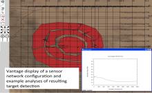
This project researched the ability to model and simulate the detection of airborne vehicles by very large sensor networks. The system includes a graphical map application, Vantage, which includes a user interface and a server capable of utilizing large HPCS resources for...
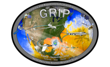
The Genesis and Rapid Intensification Processes (GRIP) experiment was a NASA Earth science field experiment in 2010 that was conducted to better understand how tropical storms form and develop into major hurricanes. NASA used the DC-8 aircraft, the WB-57 aircraft, and the...
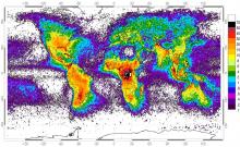
The Lightning Imaging Sensor (LIS), is a space-based instrument used to detect the distribution and variability of total lightning (cloud-to-cloud, intra-cloud, and cloud-to-ground lightning). It measures the amount, rate, and radiant energy of lightning during both day and...
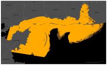
The Sediment Analysis Network for Decision Support (SANDS) project is helping resolve Gulf of Mexico Alliance (GOMA) priority issues by generating decision support products from MODIS and Landsat, data. The Geological...
