PUBLICATIONS and PRESENTATIONS
. Evaluation of Data Reduction Algorithms for Real-time assimilation and analysis. Weather Analysis and Forecasting [Internet]. 2010 . Available from: http://journals.ametsoc.org/doi/abs/10.1175/2010WAF2222296.1
. Global Hydrology Resource Center: A Foundation for Research Using Earth Observation Data. In: 61st International Astronautical Congress. 61st International Astronautical Congress. Prague, Czech Republic; 2010.
. Lightweight Advertising and Scalable Discovery of Services, Datasets, and Events Using Feedcasts and Social Tagging. In: IEEE International Geoscience & Remote Sensing Symposium. IEEE International Geoscience & Remote Sensing Symposium. Honolulu, HI.; 2010.
. Mining as a Service. In: IEEE International Geoscience & Remote Sensing Symposium. IEEE International Geoscience & Remote Sensing Symposium. Honolulu, HI; 2010.
. SCOOP Data Management: A Standards-based Distributed Information System for Coastal Data Management. In: Standards-Based Data and Information Systems for Earth Observation. Standards-Based Data and Information Systems for Earth Observation. Springer-Verlag; 2010. pp. 93-111. Available from: http://www.springerlink.com/content/h72m155753p3m2g6/
. Using Sensor Web Protocols for Environmental Data Acquisition and Management. Ecological Informatics. 2010 ;5(1):32-41.
. A Collaborative Environment for the Northern Gulf Coastal Hazards Collaboratory. Northern Gulf Institute. 2011 .
. A Collaborative Environment for the Northern Gulf Coastal Hazards Collaboratory. Northern Gulf Institute. 2011 .
. A Collaborative Multidisciplinary Environment for Coastal Science. American Geophysical Union Fall Meeting. 2011 .
. A Collaborative Multidisciplinary Environment for Coastal Science. American Geophysical Union Fall Meeting. 2011 .
. Coordinating Aircraft During NASA Airborne Science Field Campaigns. In: Earth Science Technology Forum. Earth Science Technology Forum. Pasadena, CA; 2011.
. Data Casting for Integration of Applied Science Projects. In: ESIP Winter Meeting. ESIP Winter Meeting. Washington D.C.; 2011.
. GLIDER: Application for Earth Science Data Mining and Visualization. In: Rocket City Geospatial & Alabama GIS Conference. Rocket City Geospatial & Alabama GIS Conference. Huntsville, AL; 2011.
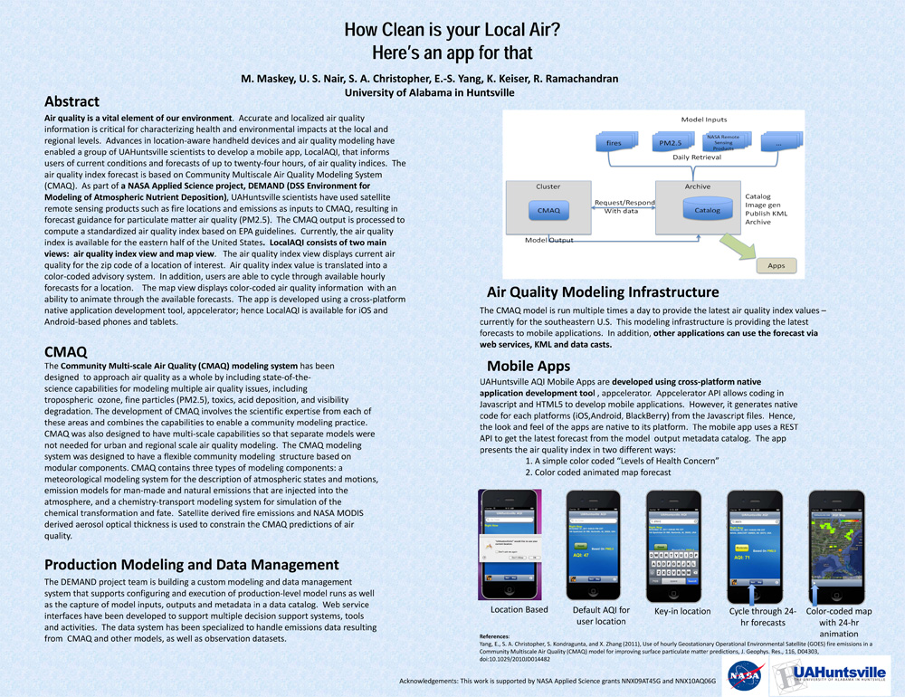
. How Clean is your Local Air? Here's an app for that. AGU 2011 [Internet]. 2011 . Available from: https://www.itsc.uah.edu/main/sites/default/files/agu2011_DEMAND-AQ-Poster.jpg
An Integrated Approach for Accessing Multiple Datasets through LANCE. 2011 Fall Meeting AGU. 2011 .
An Integrated Approach for Accessing Multiple Datasets through LANCE. 2011 Fall Meeting AGU. 2011 .
An Integrated Approach for Accessing Multiple Datasets through LANCE. 2011 Fall Meeting AGU. 2011 .
. OOSTethys / Oceans IE Service Registry Based on Catalog Service for Web. In: Geospatial Web Services: Advances in Information Interoperability. Geospatial Web Services: Advances in Information Interoperability. IGI Global; 2011.
The Use of LANCE Imagery Products to Investigate Hazards and Disasters. 2011 Fall Meeting AGU. 2011 .
The Use of LANCE Imagery Products to Investigate Hazards and Disasters. 2011 Fall Meeting AGU. 2011 .
. Augmented Reality Markup Language 2.0. In: ESIP Summer Meeting. ESIP Summer Meeting. Madison, WI; 2012.
. Collaborative Research: The Northern Gulf Coastal Hazards Collaboratory. [Internet]. 2012 . Available from: https://www.itsc.uah.edu/sites/default/files/2011_coastalhazards_poster.jpg
. Create Collaboratories for Earth Science using Talkoot. [Internet]. 2012 . Available from: https://www.itsc.uah.edu/sites/default/files/ESIPmeeting2012_Talkoot_poster.jpg
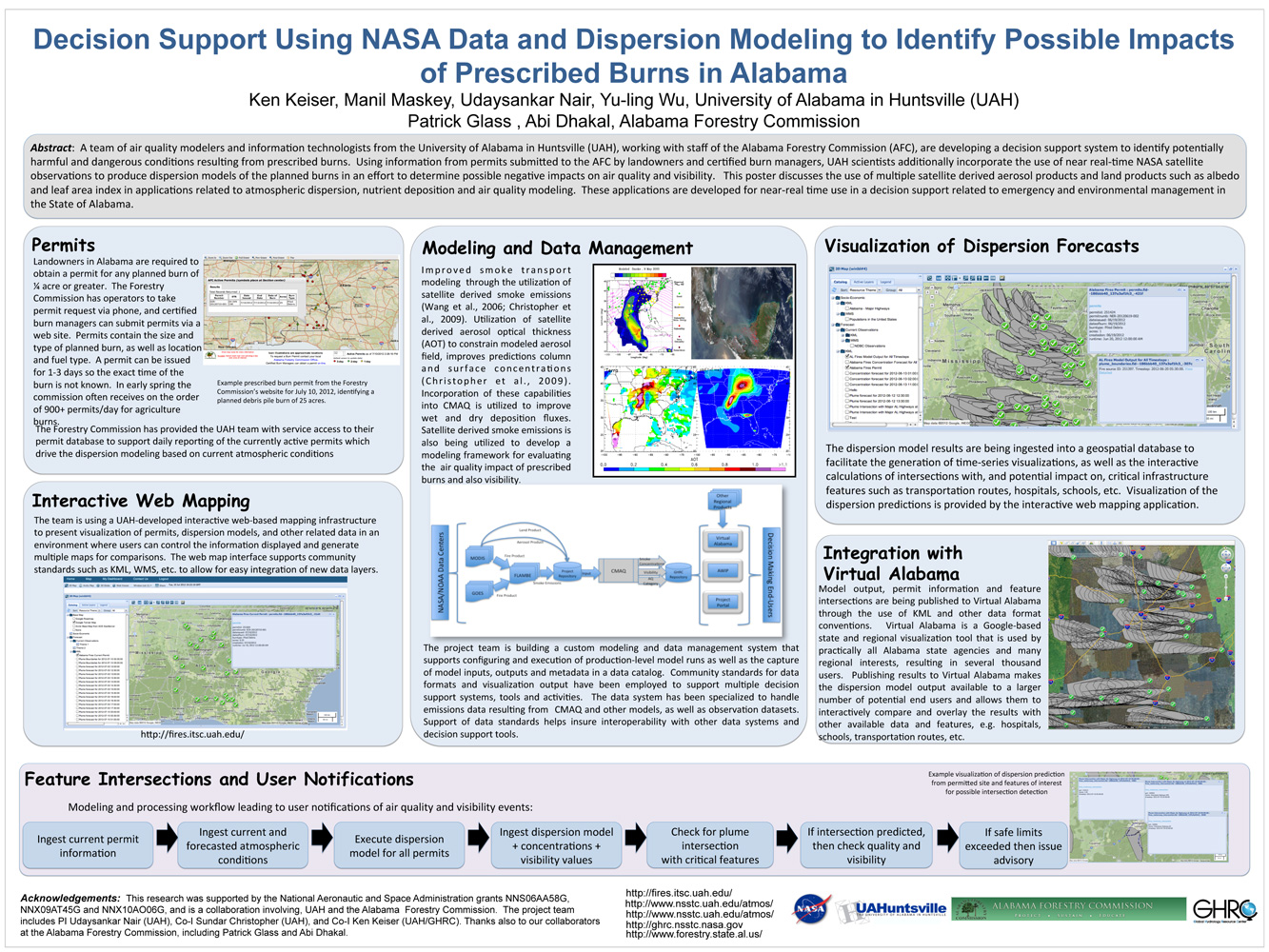
. Decision Support Using NASA Data and Dispersion Modeling to Identify Possible Impacts of Prescribed Burns in Alabama. ESIP Meeting 2012 [Internet]. 2012 . Available from: https://www.itsc.uah.edu/main/sites/default/files/Fires-for-ESIP-July-2012-v2.jpg
. Developing Mobile Apps for Drupal Sites. In: ESIP Summer Meeting. ESIP Summer Meeting. Madison, WI; 2012.
