PUBLICATIONS and PRESENTATIONS
Found 188 results
Filters: First Letter Of Last Name is M [Clear All Filters]
. Noesis: An Ontology-based Semantic Search Tool and Resource Aggregator. Geoinformatics 2006. 2006 .
. Noesis: Ontology based Scoped Search Engine and Resource Aggregator for Atmospheric Science. AGU Annual Meeting. 2006 .
. Noise Removal in FUV Imagery Data Using Context Information. IEEE Transactions on Knowledge and Data Engineering: Intelligent Data Preparation. 2005 ;17.
. Observations of Mixed-Phase Precipitation Within a CaPE Thunderstorm. Journal of Applied Meteorology. 1999 .
. Observations of Mixed-phase Precipitation Within a CaPE Thunderstorm. Conference on Cloud Physics. 1995 .
. The Observe-Orient-Decide-Act (OODA) Model For Strategic Game AI. In: The 6th International Conference on Computer Games: AI and Mobile Systems (CGAIMS 2005). The 6th International Conference on Computer Games: AI and Mobile Systems (CGAIMS 2005). Louisville, KY; 2005.
. On-Board Mining in the Sensor Web. NSF Data Mining Workshop. 2002 .
. On-Board Mining in the Sensor Web. NSF Data Mining Workshop. 2002 .
. Ontology-based Semantic Search Tool for Atmospheric Science. 22nd International Conference on Interactive Information Processing Systems (IIPS), 86th American Meteorological Society Annual Meeting. 2006 .
. OOSTethys / Oceans IE Service Registry Based on Catalog Service for Web. In: Geospatial Web Services: Advances in Information Interoperability. Geospatial Web Services: Advances in Information Interoperability. IGI Global; 2011.
. OOSTethys - Open Source Software for the Global Earth Observing Systems of Systems. In: American Geophysical Union. American Geophysical Union. San Francisco, CA; 2009. Available from: http://marinemetadata.org/community/teams/presence/presentations/agufm09-oost
. Petri Nets with Players, Strategies, and Cost: A Formalism for Modeling Cyberattacks. 2018 International Conference on Security and Management. 2018 .
. Powering Transplant Professional Collaborations with Web and Mobile Apps. Computers, Informatics, Nursing. 2013 .
. Prototyping a knowledge integration framework to solve science problems. Fall American Geophysical Union Meeting. 2007 .
. Prototyping a knowledge integration framework to solve science problems. Fall American Geophysical Union Meeting. 2007 .
. Provenance as a Guide to Understanding Science Data. IEEE International Geoscience and Remote Sensing Symposium. 2013 .
. Providing Event-Driven Real-Time Data. In: ESIP 2015 Summer Meeting. ESIP 2015 Summer Meeting. Asilomar, CA: ESIP; 2015.
. Providing Event-Driven Real-Time Data. In: ESIP 2015 Summer Meeting. ESIP 2015 Summer Meeting. Asilomar, CA: ESIP; 2015.
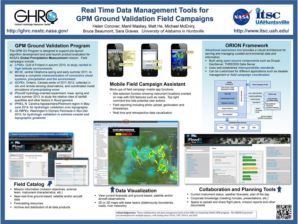
. Real Time Data Management Tools for GPM Ground Validation Field Campaigns. ESIP 2014 Winter Meeting [Internet]. 2014 . Available from: http://www.itsc.uah.edu/main/sites/default/files/GPMGV-Poster-ESIP-2014-01_sm.png
. Real Time Data Management Tools for GPM Ground Validation Field Campaigns. ESIP 2014 Winter Meeting [Internet]. 2014 . Available from: http://www.itsc.uah.edu/main/sites/default/files/GPMGV-Poster-ESIP-2014-01_sm.png
. Report on Air Quality Projects in Alabama and the Southeastern US”, . In: Geo Huntsville Conference. Geo Huntsville Conference. Huntsville, AL: Geo Huntsville Conference; 2012.
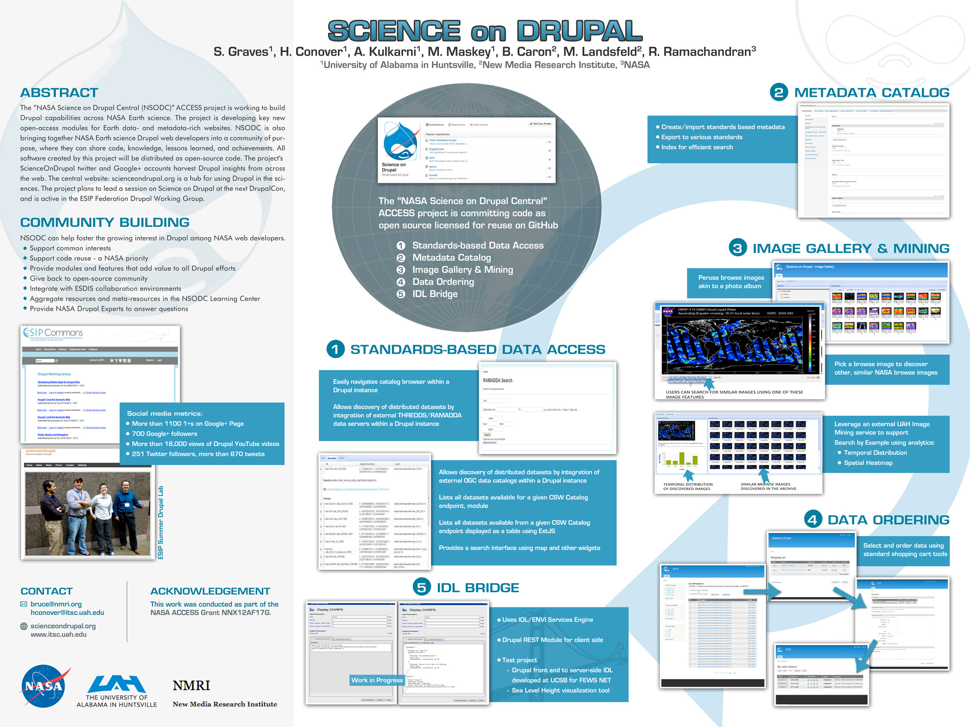
. Science on Drupal - ESIP. ESIP 2015 Winter Meeting [Internet]. 2015 . Available from: http://www.itsc.uah.edu/main/sites/default/files/sod_poster.jpg
. SCOOP Data Management: A Standards-based Distributed Information System for Coastal Data Management. In: Standards-Based Data and Information Systems for Earth Observation. Standards-Based Data and Information Systems for Earth Observation. Springer-Verlag; 2010. pp. 93-111. Available from: http://www.springerlink.com/content/h72m155753p3m2g6/
. SCOOP Data Management: A Standards-based Distributed System for Coastal Data and Modeling. IEEE International Geoscience & Remote Sensing Symposium (IGARSS '06). 2006 ;1:317-320.
