PUBLICATIONS and PRESENTATIONS
. Mapping Technologies and Innovative Applications for Emergency Operations. In: National Institute for Urban Search and Rescue (NIUSR) Fall 2001 International Conference and Exhibition. National Institute for Urban Search and Rescue (NIUSR) Fall 2001 International Conference and Exhibition. ; 2001.
. Data Interchange in a Grid Environment: The Use of the Earth Science Markup Language (ESML) in the Linked Environments for Atmospheric Discovery (LEAD). In: Supercomputing Conference 2004. Supercomputing Conference 2004. Pittsburg, PA; 2004.
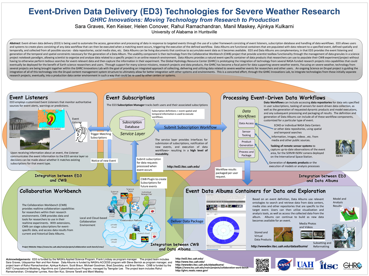
. Event-Driven Data Delivery (ED3) Technologies for Severe Weather Research, GHRC Innovations: Moving Technology from Research to Production. ESIP 2014 Winter Meeting [Internet]. 2014 . Available from: http://www.itsc.uah.edu/main/sites/default/files/ED3%2Bfor-ESIP-Jan-2014-v2_sm.png
. SERVIR at the Age of Four: The Development of an Environmental Monitoring and Visualization System for Mesoamerica. NASA Science Technology Conference [Internet]. 2007 . Available from: http://esto.nasa.gov/conferences/nstc2007/papers/Hardin_Danny_A1P4_NSTC-07-0035.pdf
. Managing and Accessing Data and Information Within EOSDIS. In: AIAA Space Programs and Technologies Conference. AIAA Space Programs and Technologies Conference. Huntsville, AL; 1992.
. Creating an Environment for Scientific Data Mining. The Society for Industrial and Applied Mathematics (SIAM) - Third Workshop on Mining Scientific Datasets. 2001 .
. The Use of PC/AT Version ORACLE in Managing Satellite Meteorological Field Program Data. Fifth International Conference on Interactive Information and Processing Systems for Meteorology, Oceanography, and Hydrology. 1989 :pp. 184-188.
. A Relational Data-Knowledge Base System and It's Potential in Developing a Distributed Data-Knowledge System. In: Conference on Artificial Intelligence for Space Applications. Conference on Artificial Intelligence for Space Applications. Huntsville, Alabama.; 1986. pp. p. 7-16.
. Mining Scientific Data using Internet as the Computer. IEEE International Geoscience & Remote Sensing Symposium (IGARSS '08). 2008 .
. A Collaborative Environment for the Northern Gulf Coastal Hazards Collaboratory. Northern Gulf Institute. 2011 .
. A Hybrid Object-based/Pixel-based Classification Approach to Detect Geophysical Phenomena. In: Second NASA Data Mining Workshop: Issues and Applications in Earth Science. Second NASA Data Mining Workshop: Issues and Applications in Earth Science. Pasadena, CA; 2006.
. Applying Advanced
Technologies for
GeoInt Solutions. Geo-Energy Summit. 2014 .
. Information Technology Research Center of the National Space Science and Technology Center. In: Technical and Business Exhibition and Symposium (TABES 2000). Technical and Business Exhibition and Symposium (TABES 2000). Huntsville, AL; 2000.
. ECITE: A Testbed for Assessment of Technology Interoperability and Integration with Architecture Components . American Geophysical Union 2016 Fall Meeting. 2016 .
. Metadata: The Golden Nuggets of Data Mining. In: First IEEE Metadata Conference. First IEEE Metadata Conference. Bethesda, Maryland; 1996.
. DISCOVERing Online Data and Services. NASA Earth Science Technology Conference. 2004 .
. Prototyping a knowledge integration framework to solve science problems. Fall American Geophysical Union Meeting. 2007 .
. Improving Performance of an Electrical Power Expert System with Genetic Algorithms. In: First International Conference on Industrial and Engineering Applications of Artificial Intelligence and Expert Systems. First International Conference on Industrial and Engineering Applications of Artificial Intelligence and Expert Systems. University of Tennessee Space Institute, Tullahoma, Tennessee; 1988. pp. pp. 298-305.
. General introduction to GIS. (). Auburn University, AL: Ala. Coop. Ext. Sys; 2000.
. Implementing GEOSS Goals in Mesoamerica through the SERVIR Project. In: Joint Assembly of the American Geophysical Union. Joint Assembly of the American Geophysical Union. Baltimore, MD; 2006.
. SERVIR: A Regional Monitoring and Decision Support System for Mesoamerica. In: Joint Assembly of the American Geophysical Union. Joint Assembly of the American Geophysical Union. Fort Lauderdale, FL; 2008.
. SANDS - Sediment Analysis Network for Decision Support. In: American Geophysical Union. American Geophysical Union. San Francisco, CA; 2010.
. Introducing Subset.Org: A Portal for Subsetting Applications and Related Tools. American Meteorological Society's (AMS) 19th International Conference on Interactive Information Processing Systems (IIPS) for Meteorology, Oceanography, and Hydrology. 2003 .
. An Overview of the Data Holdings and Information Systems Technologies of the Global Hydrology Resource Center. American Geophysical Union, December 2008. 2008 .
. Integration of Multi-Regional Data resources for Decision Support in Mesoamerica. In: International Symposium on Remote Sensing of Environment 2007. International Symposium on Remote Sensing of Environment 2007. San Jose, Costa Rica; 2007.
