PUBLICATIONS and PRESENTATIONS
. Report from the Passive Microwave Data Set Management Workshop. NASA; 2011. Available from: http://earthdata.nasa.gov/library/2011-passive-microwave-data-set-management-workshop-report
. Rule Learning Approaches for Symmetric Multiplayer Games. In: The 16th International Conference on Computer Games: AI, Animation, Mobile, Educational and Serious Games (CGAMES 2011). The 16th International Conference on Computer Games: AI, Animation, Mobile, Educational and Serious Games (CGAMES 2011). Louisville, KY: IEEE; 2011.
. Understanding Identity Exposure in Pervasive Computing Environments. Pervasive and Mobile Computing Journal. 2011 .
The Use of LANCE Imagery Products to Investigate Hazards and Disasters. 2011 Fall Meeting AGU. 2011 .
. AMSR-E SIPS
Instrument Anomaly Observations. Beltsville, MD: GSFC; 2012.
. Augmented Reality Markup Language 2.0. In: ESIP Summer Meeting. ESIP Summer Meeting. Madison, WI; 2012.
. Automated Detection of Gap Wind and Ocean Upwelling Events in Central American Gulf Regions. In: 92nd American Meteorological Society Annual Meeting. 92nd American Meteorological Society Annual Meeting. New Orleans, LA; 2012.
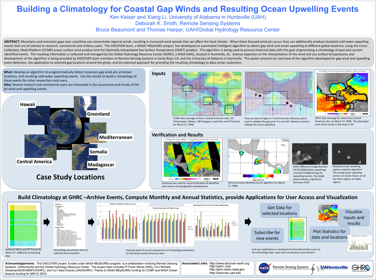
. Building a Climatology for Coastal Gap Winds and Resulting Ocean Upwelling Events. ESIP 2012 Winter Meeting [Internet]. 2012 . Available from: https://www.itsc.uah.edu/main/sites/default/files/ESIPmeeting2012_DISCOVER-GapWind-poster.jpg
. Building a Climatology for Mountain Gap Wind Jets and Related Coastal Upwelling. In: Super Computer 2012 Climate Knowledge Discovery Workshop. Super Computer 2012 Climate Knowledge Discovery Workshop. ; 2012.
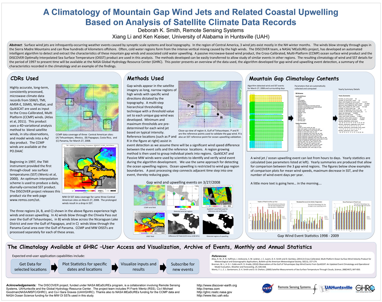
. A Climatology of Mountain Gap Wind Jets and Related Coastal Upwelling Based on Analysis of Satellite Climate Data Records. OceanSci 2012 [Internet]. 2012 . Available from: https://www.itsc.uah.edu/main/sites/default/files/OceanSci_2012_SaltLake_DISCOVER_GapWind.jpg
. Collaborative Research: The Northern Gulf Coastal Hazards Collaboratory. [Internet]. 2012 . Available from: https://www.itsc.uah.edu/sites/default/files/2011_coastalhazards_poster.jpg
. Create Collaboratories for Earth Science using Talkoot. [Internet]. 2012 . Available from: https://www.itsc.uah.edu/sites/default/files/ESIPmeeting2012_Talkoot_poster.jpg
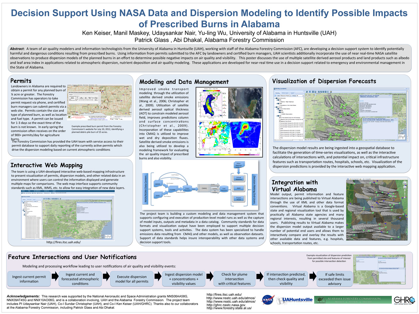
. Decision Support Using NASA Data and Dispersion Modeling to Identify Possible Impacts of Prescribed Burns in Alabama. ESIP Meeting 2012 [Internet]. 2012 . Available from: https://www.itsc.uah.edu/main/sites/default/files/Fires-for-ESIP-July-2012-v2.jpg
. Developing Mobile Apps for Drupal Sites. In: ESIP Summer Meeting. ESIP Summer Meeting. Madison, WI; 2012.
. Development of a Web-Based Mobile Technology Application for Healthcare Providers in Transplant Care. In: UA System Scholars Institute. UA System Scholars Institute. Birmingham, AL; 2012.
. Disaster Response and Analysis Through Event-Driven Data Delivery (ED3) Technology – an Overview. SERVIR Summit. 2012 .
. GLIDER: A Platform for Remote Sensing Data Visualization/Fusion/Analysis. In: Hyperspectral & Polarimetric Community Collaboration Workshop. Hyperspectral & Polarimetric Community Collaboration Workshop. Huntsville, AL; 2012. Available from: http://smapcenter.uah.edu/SMAP-CENTER/Conferences/HyperPolar2012/index.html
. A Large Scale Sensor Network Simulation for Aircraft/Missile Detection/Tracking. In: Hyperspectral & Polarimetric Community Collaboration Workshop. Hyperspectral & Polarimetric Community Collaboration Workshop. Huntsville, AL; 2012. Available from: http://smapcenter.uah.edu/SMAP-CENTER/Conferences/HyperPolar2012/index.html
Mapping the biosphere: exploring species to understand the origin, organization and sustainability of biodiversity. Systematics and Biodiversity. 2012 ;10(1):1-20.
. A Metadata Catalog for the Northern Gulf Coastal Hazards Collaboratory. Northern Gulf Coastal Hazards Collaboratory Annual Meeting. 2012 .
. A Metadata Catalog for the Northern Gulf Coastal Hazards Collaboratory. [Internet]. 2012 . Available from: https://www.itsc.uah.edu/sites/default/files/2011_coastalhazards_poster.jpg
. Mine Your Data: GLIDER brings data mining to the masses. [Internet]. 2012 . Available from: https://www.itsc.uah.edu/sites/default/files/esipmeeting2011_glider.jpg
. Orion: An Open Source Collaborative Framework. In: Geo Huntsville Conference. Geo Huntsville Conference. Huntsville, AL: Geo Huntsville Conference; 2012.
. Passive Microwave Data Set Management Workshop. [Internet]. 2012 ;24(1):30-31. Available from: http://eospso.gsfc.nasa.gov/eos_homepage/for_scientists/earth_observer.php
