PUBLICATIONS and PRESENTATIONS
Found 331 results
Filters: First Letter Of Last Name is G [Clear All Filters]
. SERVIR: A Regional Monitoring and Decision Support System for Mesoamerica. In: Joint Assembly of the American Geophysical Union. Joint Assembly of the American Geophysical Union. Fort Lauderdale, FL; 2008.
Service-Oriented Environments in Research and Education for Dynamically Interacting with Mesoscale Weather. IEEE Computing in Science & Engineering. 2005 ;7:24-32.
Service-Oriented Environments in Research and Education for Dynamically Interacting with Mesoscale Weather. IEEE Computing in Science & Engineering. 2005 ;7:24-32.
. Service Oriented Architecture for Harvesting Distributed Data Repositories. NASA Earth Science Technology Conference [Internet]. 2006 . Available from: http://esto.nasa.gov/conferences/estc2006/papers/a4p3.pdf
. Sensor networks and network sensibility. In: SPIE Defense and Security Symposium 2007. SPIE Defense and Security Symposium 2007. Orlando, FL; 2007.
. The Sensor Management for Applied Research Technologies (SMART) Project. NASA Science Technology Conference [Internet]. 2007 . Available from: http://esto.nasa.gov/conferences/nstc2007/papers/Goodman_Michael__A1P1_NSTC-07-0120.pdf
. A Semantic Approach for Knowledge Discovery to Help Mitigate Habitat Loss in the Gulf of Mexico. In: American Geophysical Union (AGU) Fall meeting. American Geophysical Union (AGU) Fall meeting. San Francisco, CA; 2008.
. Semanitcs and Earth Science Markup Language. Earth Science Technology Conference. 2003 .
. SCOOP Data Management: A Standards-based Distributed System for Coastal Data and Modeling. IEEE International Geoscience & Remote Sensing Symposium (IGARSS '06). 2006 ;1:317-320.
. SCOOP Data Management: A Standards-based Distributed Information System for Coastal Data Management. In: Standards-Based Data and Information Systems for Earth Observation. Standards-Based Data and Information Systems for Earth Observation. Springer-Verlag; 2010. pp. 93-111. Available from: http://www.springerlink.com/content/h72m155753p3m2g6/
. Science-Driven Workbench . NSF EarthCube All Hands Meeting. 2017 .
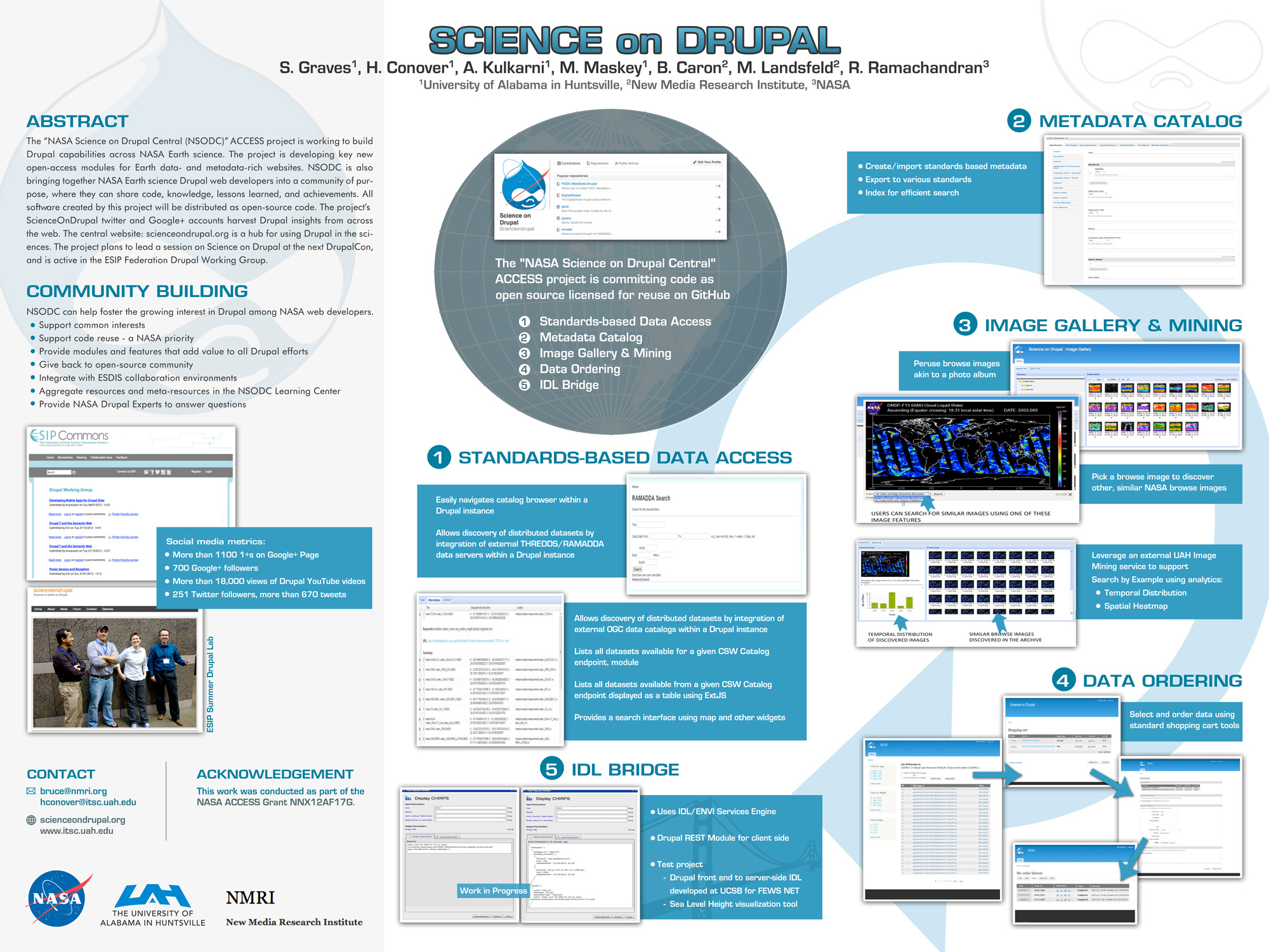
. Science on Drupal - ESIP. ESIP 2015 Winter Meeting [Internet]. 2015 . Available from: http://www.itsc.uah.edu/main/sites/default/files/sod_poster.jpg
. Science Data Processing for the Advanced Microwave Scanning Radiometer-Earth Observing System. International Society for Optical Science and Technology (SPIE) 49th Annual Meeting (Atmospheric and Environmental Remote Sensing Data Processing and Utilization: an End-to-End System Perspective). 2004 ;vol. 5548:pp. 195-206.
. SANDS - Sediment Analysis Network for Decision Support. In: American Geophysical Union. American Geophysical Union. San Fancisco, CA; 2009. Available from: http://adsabs.harvard.edu/abs/2009AGUFMNH11A1106H
. The Role of Data Mining in Earth Science Data Interoperability. ASPRS Annual Conference, Conference on Remote Sensing Education (CORSE), Education for the Next Millennium. 1999 .
. Retrieval of Cloud Properties Using Lightning Observations from Space. American Geophysical Union Meeting. 1995 .
. Responding to Exponentially Increasing Demand: Modernizing NOAA's Data and Information System. University Corporation for Atmospheric Research Data Management Panel with final report issued to the U.S. Congress, Boulder, Colorado; 1994.
. A Relational Data-Knowledge Base System and It's Potential in Developing a Distributed Data-Knowledge System. In: Conference on Artificial Intelligence for Space Applications. Conference on Artificial Intelligence for Space Applications. Huntsville, Alabama.; 1986. pp. p. 7-16.
. Real-time target tracking with binary sensor networks and parallel computing. In: IEEE International Conference on Granular Computing. IEEE International Conference on Granular Computing. Atlanta, GA; 2006.
. Real-time target tracking simulations in large disparate sensor networks. In: SPIE Defense and Security Symposium 2007. SPIE Defense and Security Symposium 2007. Orlando, FL; 2007.
. Real-time Storm Detection and Weather Forecast Activation through Data Mining and Events Processing. Earth Science Informatics. 2007 ;1:49-57.
. The Real Time Mission Monitor - A Situational Awareness Tool for Managing Experiment Assets. NASA Science Technology Conference [Internet]. 2007 . Available from: http://esto.nasa.gov/conferences/nstc2007/papers/Goodman_Michael_A3P2.pdf
. The Real Time Mission Monitor: A Platform for Real Time Environmental Data Integration and Display during NASA Field Campaigns. In: Joint Assembly of the American Geophysical Union. Joint Assembly of the American Geophysical Union. Fort Lauderdale, FL; 2008.
. The Real Time Mission Monitor: A Platform for Real Time Environmental Data Integration and Display during NASA Field Campaigns. In: Joint Assembly of the American Geophysical Union. Joint Assembly of the American Geophysical Union. Fort Lauderdale, FL; 2008.
