PUBLICATIONS and PRESENTATIONS
. NASA Workshop on Issues in the Application of Data Mining to Scientific Data, Final Report. University of Alabama in Huntsville; 1999.
. General introduction to GIS. (). Auburn University, AL: Ala. Coop. Ext. Sys; 2000.
. Critical BMD System and Sensor Concept Analysis Technical Assistance. EC Corporation, Final Report, Contract No. 5-31426, UAH-CAO-0001; 1986.
. 2nd NASA Data Mining Workshop: Issues and Applications in Earth Science. Pasadena, CA: NASA; 2006. Available from: http://datamining.itsc.uah.edu/meeting06/docs/2nd_NASA_Data_Mining_D694F.pdf
. 2nd NASA Data Mining Workshop: Issues and Applications in Earth Science. Pasadena, CA: NASA; 2006. Available from: http://datamining.itsc.uah.edu/meeting06/docs/2nd_NASA_Data_Mining_D694F.pdf
. Using Satellite Lightning Data as a Hands-On Activity for a Broad Audience . American Geophysical Union 2017 Fall Meeting. 2017 .
. Supporting the Use of GPM-GV Field Campaign Data Beyond Project Scientists . American Geophysical Union 2017 Fall Meeting. 2017 .
. Event-Driven Virtual Collections for Community Solutions . ESIP Winter Meeting, Washington, D.C. 2017 .
. Enhancing Spatial Resolution of Remotely Sensed Imagery Using Deep Learning . AGU Fall Meeting, New Orleans, LA. 2017 .
. Enhancing Spatial Resolution of Remotely Sensed Imagery Using Deep Learning . AGU Fall Meeting, New Orleans, LA. 2017 .
. Drowning in Data: Going Beyond Traditional Data Archival to Educate Data Users . American Geophysical Union 2017 Fall Meeting. 2017 .
. Data Preparedness for Disasters, Hazards and Other Events . ESIP Winter Meeting. 2017 .
. Virtual Collections: An Earth Science Data Curation Service. American Geophysical Union 2016 Fall Meeting. 2016 .
. Virtual Collections: An Earth Science Data Curation Service. American Geophysical Union 2016 Fall Meeting. 2016 .
. Using NASA Earth Observations within DHIS2 to support Malaria Control Decisions. American Meteorological Society. 2020 .
. Using NASA Earth Observations within DHIS2 to support Malaria Control Decisions. American Meteorological Society. 2020 .
. Using Earth Observations within a Health Management Information System for Improving Malaria Decision Support. American Geophysical Union. 2019 .
. Using Earth Observations within a Health Management Information System for Improving Malaria Decision Support. American Geophysical Union. 2019 .
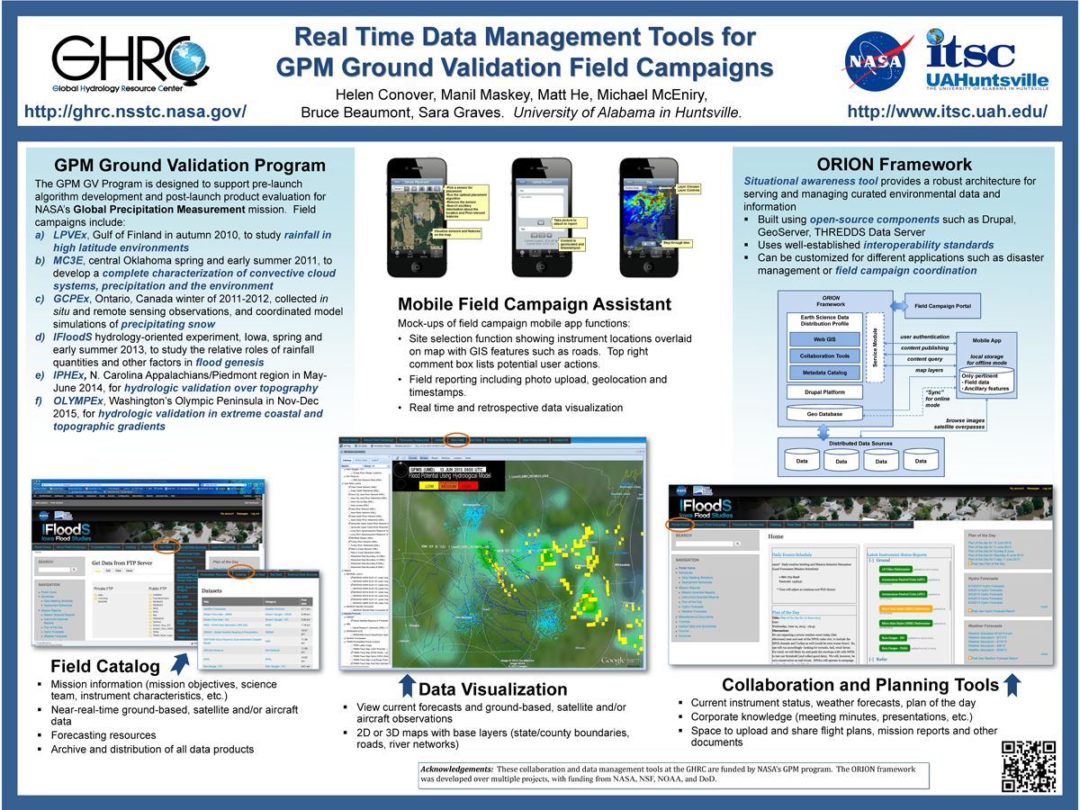
. Real Time Data Management Tools for GPM Ground Validation Field Campaigns. ESIP 2014 Winter Meeting [Internet]. 2014 . Available from: http://www.itsc.uah.edu/main/sites/default/files/GPMGV-Poster-ESIP-2014-01_sm.png
. Provenance Collection and Display for the AMSR-E SIPS. [Internet]. 2012 . Available from: https://www.itsc.uah.edu/sites/default/files/ESIPmeeting2012_ProvenancePoster_0.jpg
. Mine Your Data: GLIDER brings data mining to the masses. [Internet]. 2012 . Available from: https://www.itsc.uah.edu/sites/default/files/esipmeeting2011_glider.jpg
. Making connections: Where STEM learning and Earth science data services meet. American Geophysical Union 2016 Fall Meeting. 2016 .
. Lightning Imaging Sensor (LIS) on the International Space Station (ISS) Activation, Assessment and Operation in the First Six Months . International Space Station Research & Development (ISS&RD). 2017 .
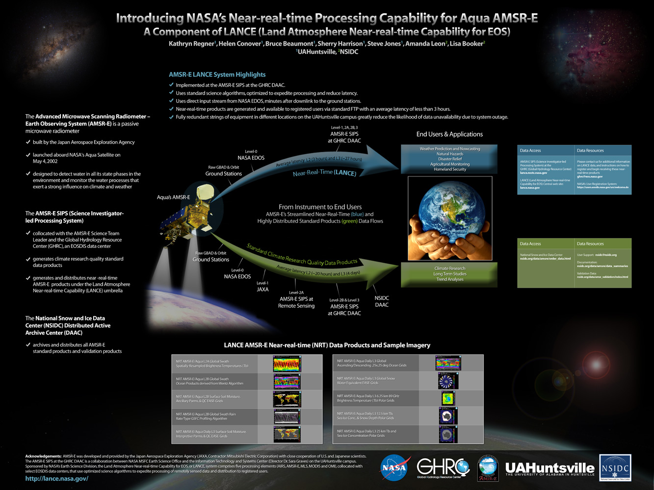
. Introducing NASA's Near-real-time Processing Capability for Aqua AMSR-E . [Internet]. 2010 . Available from: http://www.itsc.uah.edu/main/sites/default/files/lance_poster.jpg
