PUBLICATIONS and PRESENTATIONS
Found 158 results
Filters: First Letter Of Last Name is B [Clear All Filters]
. Distributed Architecture Design Environment. Technical and Business Exhibition and Symposium. 1986 .
. Discovering and Accessing Data from the Federation of Earth Science Information Partners. Eos, Transactions, AGU. 2002 ;Vol. 83.
. DISCOVER: A Service Oriented Approach to Managing Earth Science Data Across Distributed Project-specific Repositories. AGU 2008 Fall Meeting. 2008 .
. Disaster Event-Based Data Collections with ArcGIS Online Data Processing . Esri Annual User's Conference. 2017 .
. Development of a Deep Learning Super-Resolution Generative Adversarial Network (SGAN) for Improving the Resolution of Global Precipitation Measurement (GPM) Dual-Frequency Precipitation Radar (DPR) Data. American Geophysical Union. 2019 .
. Development of a Deep Learning Super-Resolution Generative Adversarial Network (SGAN) for Improving the Resolution of Global Precipitation Measurement (GPM) Dual-Frequency Precipitation Radar (DPR) Data. American Geophysical Union. 2019 .
. Deep Learning for Multisensor Image Resolution Enhancement. In: GeoAI’17: 1st ACM SIGSPATIAL Workshop on Artificial Intelligence and Deep Learning for Geographic Knowledge Discovery. GeoAI’17: 1st ACM SIGSPATIAL Workshop on Artificial Intelligence and Deep Learning for Geographic Knowledge Discovery. Redondo Beach, CA USA: ACM; 2017.
. Deep Learning for Multisensor Image Resolution Enhancement. In: GeoAI’17: 1st ACM SIGSPATIAL Workshop on Artificial Intelligence and Deep Learning for Geographic Knowledge Discovery. GeoAI’17: 1st ACM SIGSPATIAL Workshop on Artificial Intelligence and Deep Learning for Geographic Knowledge Discovery. Redondo Beach, CA USA: ACM; 2017.
. A Dataset-Independent Subsetting Prototype. In: HDF-EOS Vendors Workshop. HDF-EOS Vendors Workshop. Goddard Space Flight Center; 1997.
. Data Systems for the HS3 Field Campaign. ESIP 2015 Winter Meeting [Internet]. 2015 . Available from: http://www.itsc.uah.edu/main/posters/data-system-hs3-field-campaign-agu-2014
. Data Preparedness for Disasters, Hazards and Other Events . ESIP Winter Meeting. 2017 .
Data Assimilation Decision Making Using Sensor Web Enablement. In: SPoRT Data Assimilation Workshop. SPoRT Data Assimilation Workshop. Marshall Space Flight Center; 2009. Available from: http://weather.msfc.nasa.gov/sport/workshops/da_2009/Maskey_DA_Data.ppt
Data Assimilation Decision Making Using Sensor Web Enablement. In: SPoRT Data Assimilation Workshop. SPoRT Data Assimilation Workshop. Marshall Space Flight Center; 2009. Available from: http://weather.msfc.nasa.gov/sport/workshops/da_2009/Maskey_DA_Data.ppt
Data Assimilation Decision Making Using Sensor Web Enablement. In: SPoRT Data Assimilation Workshop. SPoRT Data Assimilation Workshop. Marshall Space Flight Center; 2009. Available from: http://weather.msfc.nasa.gov/sport/workshops/da_2009/Maskey_DA_Data.ppt
. Data Albums: A synthesis engine to support case study and climatology analysis. In: AGU. AGU. San Francisco, CA: AGU; 2013.
. Critical BMD System and Sensor Concept Analysis Technical Assistance. EC Corporation, Final Report, Contract No. 5-31426, UAH-CAO-0001; 1986.
. Coordinating Aircraft During NASA Airborne Science Field Campaigns. In: Earth Science Technology Forum. Earth Science Technology Forum. Pasadena, CA; 2011.
. Converting Soil Survey Maps into Digital Products . lights of Agricultural Research, Alabama Agricultural Experiment Station. 2000 ;48(1).
. Composition of Cyberattack Model. 31st International Conference on Computer Applications in Industry and Engineering. 2018 :3-8.
. Component-based Implementation of Cyberattack Simulation Models. 2019 ACM Southeast Conference. 2019 :64-71.
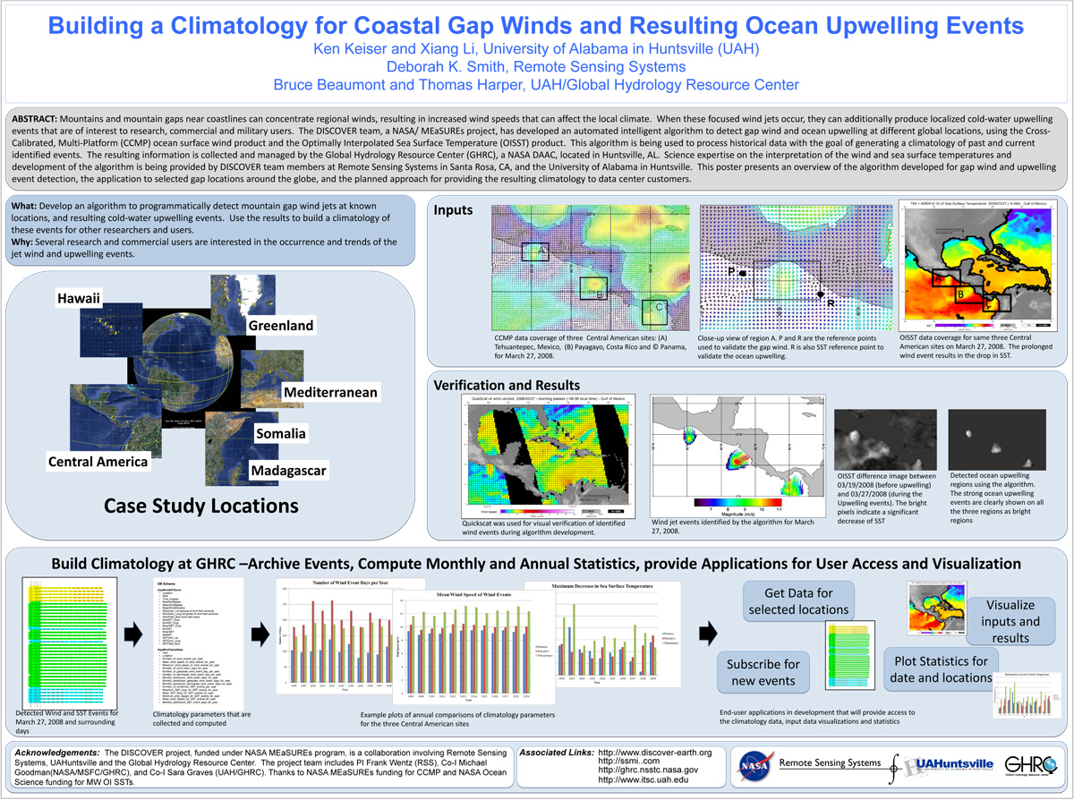
. Building a Climatology for Coastal Gap Winds and Resulting Ocean Upwelling Events. ESIP 2012 Winter Meeting [Internet]. 2012 . Available from: https://www.itsc.uah.edu/main/sites/default/files/ESIPmeeting2012_DISCOVER-GapWind-poster.jpg
. Atmospheric and Environmental Remote Sensing Data Processing and Utilization: an End-to-End System Perspective. International Society for Optical Science and Technology (SPIE) 49th Annual Meeting (Instruments, Methods, and Missions for Astrobiology VIII). 2004 .
. Atlantic Tropical Cyclone Monitoring with AMSU-A: Estimation of Maximum Sustained Wind Speeds. Monthly Weather Review. 2001 ;129:pp. 1518-1532.
. Application of EarlyLEAD to Study QPF Across the Mid-Atlantic. In: LEAD NSF Site Review. LEAD NSF Site Review. University of Illinois, Urbana Champaign; 2005.
. Application of EarlyLEAD to Study QPF Across the Mid-Atlantic. In: LEAD NSF Site Review. LEAD NSF Site Review. University of Illinois, Urbana Champaign; 2005.
