PUBLICATIONS and PRESENTATIONS
Found 85 results
Filters: Author is Sara Graves [Clear All Filters]
. Evaluation of Data Reduction Algorithms for Real-time assimilation and analysis. Weather Analysis and Forecasting [Internet]. 2010 . Available from: http://journals.ametsoc.org/doi/abs/10.1175/2010WAF2222296.1
. Event-based Technologies. GeoHSV/GeoInt TechVet2. 2014 .
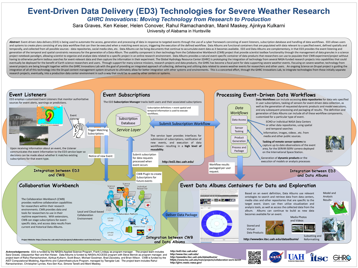
. Event-Driven Data Delivery (ED3) Technologies for Severe Weather Research, GHRC Innovations: Moving Technology from Research to Production. ESIP 2014 Winter Meeting [Internet]. 2014 . Available from: http://www.itsc.uah.edu/main/sites/default/files/ED3%2Bfor-ESIP-Jan-2014-v2_sm.png
. Evolving Frameworks for Different Communities of Scientists and End Users . American Geophysical Union 2016 Fall Meeting. 2016 .
. Expanding the Role of an Earth Science Data System: The GHRC Innovations Lab. In: AGU. AGU. San Francisco, CA: AGU; 2013.
. GLIDER: A comprehensive software tool to visualize, analyze and mine satellite imagery. In: IEEE International Geoscience & Remote Sensing Symposium. IEEE International Geoscience & Remote Sensing Symposium. Cape Town, South Africa; 2009. Available from: http://wiki.esipfed.org/index.php/GLIDER:_A_comprehensive_software_tool_to_visualize,_analyze_and_mine_satellite_imagery
. GLIDER: A Platform for Remote Sensing Data Visualization/Fusion/Analysis. In: Hyperspectral & Polarimetric Community Collaboration Workshop. Hyperspectral & Polarimetric Community Collaboration Workshop. Huntsville, AL; 2012. Available from: http://smapcenter.uah.edu/SMAP-CENTER/Conferences/HyperPolar2012/index.html
. GLIDER: Application for Earth Science Data Mining and Visualization. In: Rocket City Geospatial & Alabama GIS Conference. Rocket City Geospatial & Alabama GIS Conference. Huntsville, AL; 2011.
. GLIDER: Earth Science Image Visualization and Analysis. 2010 [Internet]. 2010 . Available from: https://www.itsc.uah.edu/main/sites/default/files/glider_poster.jpg
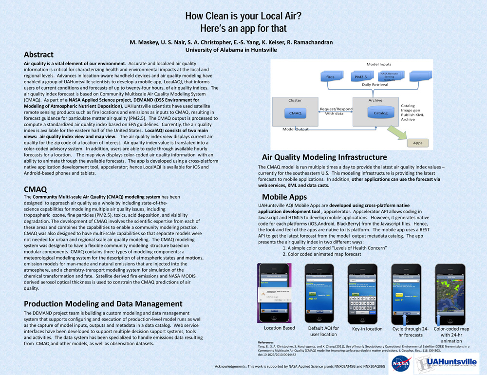
. How Clean is your Local Air? Here's an app for that. AGU 2011 [Internet]. 2011 . Available from: https://www.itsc.uah.edu/main/sites/default/files/agu2011_DEMAND-AQ-Poster.jpg
. An Improved Data Reduction Tool in Support of the Real-Time Assimilation of NASA Satellite Data Streams. AMS Annual Meeting. 2008 .
. An Improved Data Reduction Tool in Support of the Real-Time Assimilation of NASA Satellite Data Streams. AMS Annual Meeting. 2007 .
. An Improved Data Reduction Tool in Support of the Real-Time Assimilation of NASA Satellite Data Streams. NASA Science Technology Conference. 2007 .
. INSIGHT: Analysis Using Multiple Sensor Assets. In: Emerging and Enabling Technology Conference. Emerging and Enabling Technology Conference. Huntsville, AL; 2009.
Instant Karma Status Update: Provenance at the AMSR-E SIPS. [Internet]. 2011 . Available from: https://www.itsc.uah.edu/sites/default/files/karma_poster.jpg
. Intelligent Data Thinning Algorithm for Earth System Numerical Model Research and Application. 21st International Conference on Interactive Information Processing Systems (IIPS) for Meteorology, Oceanography, and Hydrology, 85th AMS Annual Meeting. 2005 .
. Intelligent Data Thinning Algorithms for Satellite Imagery. IEEE International Geoscience & Remote Sensing Symposium (IGARSS '08). 2008 .
. Interchange Technology for Applications to facilitate generic access to heterogeneous data formats. IEEE International Geoscience and Remote Sensing Symposium (IGARSS '02) and the 24th Canadian Symposium on Remote Sensing. 2002 .
. An Interoperable Framework for Mining and Analysis of Space Science Data (F-MASS). NASA AISRP Workshop. 2003 .
. Introducing Provenance Capture into a Legacy Data System. IEEE Transactions on Geoscience and Remote Sensing. 2013 ;51(11).
. Investigating Data Mining Techniques to Detect Dust Storms in MODIS Imagery. 32nd International Symposium on Remote Sensing of Environment. 2007 .
. ISO Lineage Metadata at the AMSR-E SIPS. ESIP Federation Winter Meeting 2013 [Internet]. 2013 . Available from: http://commons.esipfed.org/node/1037
. Key Provenance of Earth Science Observational Data Products. American Geophysical Union. 2011 .
. A Large Scale Sensor Network Simulation for Aircraft/Missile Detection/Tracking. In: Hyperspectral & Polarimetric Community Collaboration Workshop. Hyperspectral & Polarimetric Community Collaboration Workshop. Huntsville, AL; 2012. Available from: http://smapcenter.uah.edu/SMAP-CENTER/Conferences/HyperPolar2012/index.html
. Large-Scale Sensor Network Simulations for Air Defense Studies. In: Emerging and Enabling Technology Conference. Emerging and Enabling Technology Conference. Huntsville, AL; 2009.
