PUBLICATIONS and PRESENTATIONS
. Emergent Science: Accelerating the scientific process via simple collaborative interactions. In: Geological Society of America Annual Meeting. Geological Society of America Annual Meeting. Denver, CO; 2010.
. Generic Instrumentation for OPM-Driven Provenance Interoperability in the Geosciences. Journal of Future Generation Computer Systems. 2010 .
. GLIDER: Earth Science Image Visualization and Analysis. 2010 [Internet]. 2010 . Available from: https://www.itsc.uah.edu/main/sites/default/files/glider_poster.jpg
. Global Hydrology Resource Center: A Foundation for Research Using Earth Observation Data. In: 61st International Astronautical Congress. 61st International Astronautical Congress. Prague, Czech Republic; 2010.
. GRIP Collaboration Portal: Information Management for a Hurricane Field Campaign. In: American Geophysical Union. American Geophysical Union. ; 2010.
. Instant Karma: Collecting Provenance for AMSR-E. In: AMSR-E Science Team Meeting. AMSR-E Science Team Meeting. Huntsville, AL; 2010.
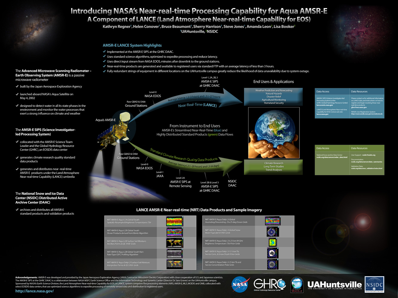
. Introducing LANCE, NASA’s Near-real-time Processing Capability for Aqua AMSR-E. In: American Geophysical Union. American Geophysical Union. San Francisco, CA; 2010.
. Introducing NASA's Near-real-time Processing Capability for Aqua AMSR-E . [Internet]. 2010 . Available from: http://www.itsc.uah.edu/main/sites/default/files/lance_poster.jpg
. LANCE AMSR-E Status. College Park, MD: LANCE User Working Group Meeting; 2010.
. Near-real-time processing for Aqua AMSR-E data. [Internet]. 2010 . Available from: https://www.itsc.uah.edu/sites/default/files/lance_poster.jpg
. Satellite Data Driven Modeling System for Predicting Air Quality and Visibility During Wildfires and Prescribed Burn Events. In: NASA Applied Science Program Gulf of Mexico Region Workshop. NASA Applied Science Program Gulf of Mexico Region Workshop. New Orleans, LA; 2010.
. SCOOP Data Management: A Standards-based Distributed Information System for Coastal Data Management. In: Standards-Based Data and Information Systems for Earth Observation. Standards-Based Data and Information Systems for Earth Observation. Springer-Verlag; 2010. pp. 93-111. Available from: http://www.springerlink.com/content/h72m155753p3m2g6/
. Using Sensor Web Protocols for Environmental Data Acquisition and Management. Ecological Informatics. 2010 ;5(1):32-41.
. Utilization of Near Real-time Satellite Data in Atmospheric Transport and Dispersion Modeling Applications. In: 2010 AGU Fall Meeting. 2010 AGU Fall Meeting. San Francisco, CA; 2010.
The 2nd Generation Real Time Mission Monitor (RTMM) Development. In: American Geophysical Union. American Geophysical Union. San Francisco, CA; 2009. Available from: http://adsabs.harvard.edu/abs/2009AGUFMIN33A1026B
Data Assimilation Decision Making Using Sensor Web Enablement. In: SPoRT Data Assimilation Workshop. SPoRT Data Assimilation Workshop. Marshall Space Flight Center; 2009. Available from: http://weather.msfc.nasa.gov/sport/workshops/da_2009/Maskey_DA_Data.ppt
. Demo III Collaborative workflows in earth science data mining. In: 2009 International Symposium on Collaborative Technologies and Systems. 2009 International Symposium on Collaborative Technologies and Systems. Baltimore, MD: IEEE Computer Society; 2009. Available from: http://portal.acm.org/citation.cfm?id=1581308
. Emergent Science: Solving Complex Science Problems via Collaborations. In: American Geophysical Union. American Geophysical Union. San Francisco, CA; 2009. Available from: http://adsabs.harvard.edu/abs/2009AGUFMED13E.05L
. GLIDER: A comprehensive software tool to visualize, analyze and mine satellite imagery. In: IEEE International Geoscience & Remote Sensing Symposium. IEEE International Geoscience & Remote Sensing Symposium. Cape Town, South Africa; 2009. Available from: http://wiki.esipfed.org/index.php/GLIDER:_A_comprehensive_software_tool_to_visualize,_analyze_and_mine_satellite_imagery
. GLIDER: A comprehensive software tool to visualize, analyze and mine satellite imagery. In: IEEE International Geoscience & Remote Sensing Symposium. IEEE International Geoscience & Remote Sensing Symposium. Cape Town, South Africa; 2009. Available from: http://wiki.esipfed.org/index.php/GLIDER:_A_comprehensive_software_tool_to_visualize,_analyze_and_mine_satellite_imagery
. GLIDER: Free Tool Imagery Data Visualization, Analysis and Mining. In: American Geophysical Union. American Geophysical Union. San Francisco, CA; 2009. Available from: http://adsabs.harvard.edu/abs/2009AGUFMIN51C.07R
. Large-Scale Sensor Network Simulations for Air Defense Studies. In: Emerging and Enabling Technology Conference. Emerging and Enabling Technology Conference. Huntsville, AL; 2009.
. SANDS - Sediment Analysis Network for Decision Support. In: American Geophysical Union. American Geophysical Union. San Fancisco, CA; 2009. Available from: http://adsabs.harvard.edu/abs/2009AGUFMNH11A1106H
. Service Oriented Architecture for Data Mining at Data Centers and Computing Centers. Cloud Computing and Collaborative Technologies in Geosciences. 2009 .
. A Survey of NASA's Tropical Atmospheric Research Field Campaigns. In: American Geophysical Union. American Geophysical Union. San Francisco, CA; 2009. Available from: http://adsabs.harvard.edu/abs/2009AGUFM.A51H0208Y
