PUBLICATIONS and PRESENTATIONS
Found 229 results
Filters: First Letter Of Last Name is C [Clear All Filters]
. Provenance Collection and Display Tools for the AMSR-E SIPS. In: NASA Earth Science Data Systems Working Groups (ESDSWG) Meeting. NASA Earth Science Data Systems Working Groups (ESDSWG) Meeting. Newport News, VA; 2011.
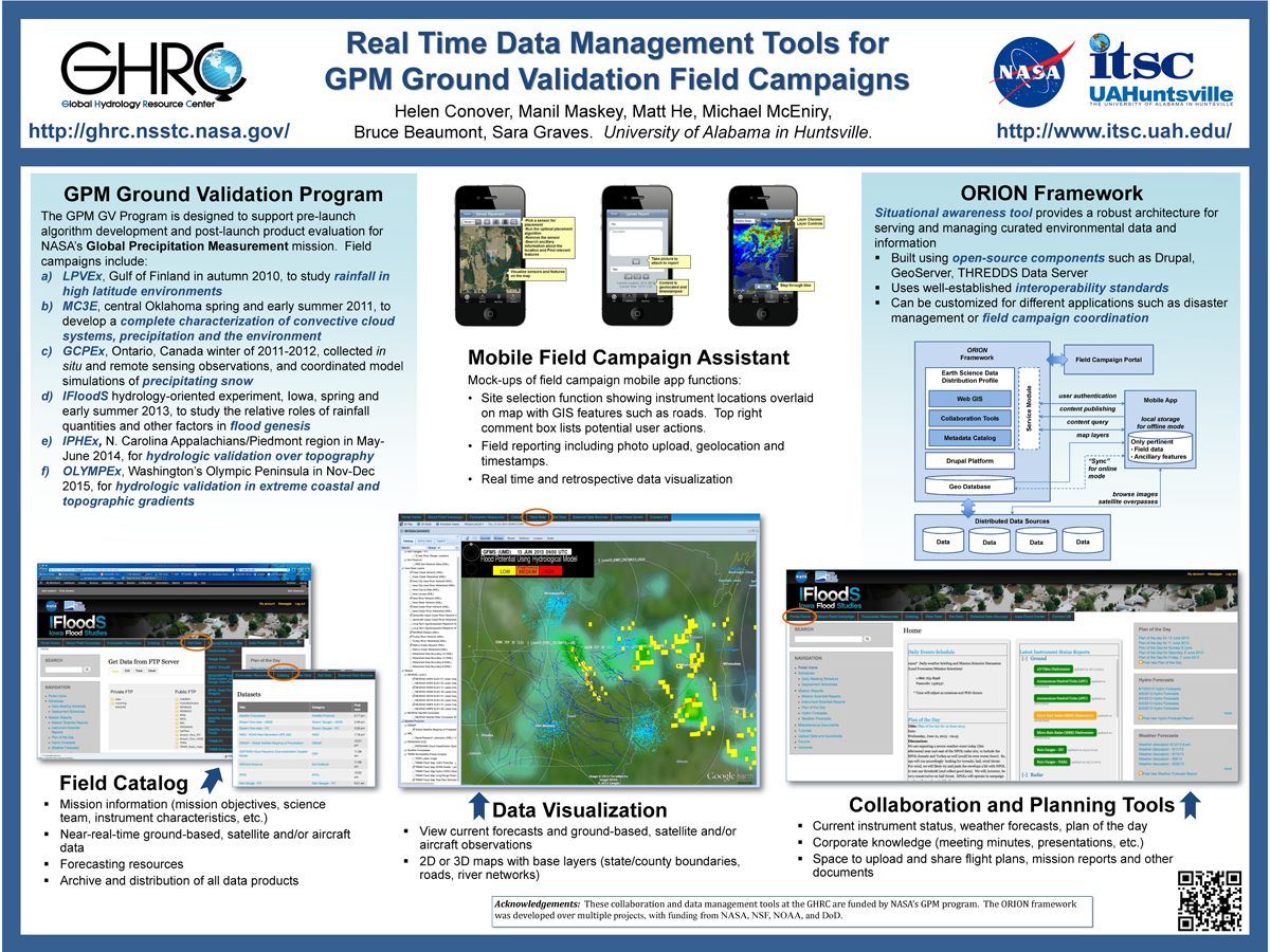
. Real Time Data Management Tools for GPM Ground Validation Field Campaigns. ESIP 2014 Winter Meeting [Internet]. 2014 . Available from: http://www.itsc.uah.edu/main/sites/default/files/GPMGV-Poster-ESIP-2014-01_sm.png
. Real-time Storm Detection and Weather Forecast Activation through Data Mining and Events Processing. Earth Science Informatics. 2007 ;1:49-57.
. Real-time target tracking simulations in large disparate sensor networks. In: SPIE Defense and Security Symposium 2007. SPIE Defense and Security Symposium 2007. Orlando, FL; 2007.
. Real-time target tracking with binary sensor networks and parallel computing. In: IEEE International Conference on Granular Computing. IEEE International Conference on Granular Computing. Atlanta, GA; 2006.
. Reciprocity Attacks. In: Symposium on Usable Privacy and Security. Symposium on Usable Privacy and Security. Carnegie Mellon University Campus; 2011.
. Report from the Passive Microwave Data Set Management Workshop. NASA; 2011. Available from: http://earthdata.nasa.gov/library/2011-passive-microwave-data-set-management-workshop-report
. Report on Air Quality Projects in Alabama and the Southeastern US”, . In: Geo Huntsville Conference. Geo Huntsville Conference. Huntsville, AL: Geo Huntsville Conference; 2012.
. The Role of Data Mining in Earth Science Data Interoperability. ASPRS Annual Conference, Conference on Remote Sensing Education (CORSE), Education for the Next Millennium. 1999 .
. SANDS - Sediment Analysis Network for Decision Support. In: American Geophysical Union. American Geophysical Union. San Fancisco, CA; 2009. Available from: http://adsabs.harvard.edu/abs/2009AGUFMNH11A1106H
. Satellite Data Driven Modeling System for Predicting Air Quality and Visibility During Wildfires and Prescribed Burn Events. In: NASA Applied Science Program Gulf of Mexico Region Workshop. NASA Applied Science Program Gulf of Mexico Region Workshop. New Orleans, LA; 2010.
. Satellite Remote Sensing of Fires, Smoke and Regional Radiative Energy Budgets Over South America and Africa. International Symposium on Optical Science, Engineering and Instrumentation (SPIE). 1999 ;3756:519-528.
. Satellite Remote Sensing of Fires, Smoke and Regional Radiative Energy Budgets Over South America and Africa. International Symposium on Optical Science, Engineering and Instrumentation (SPIE). 1999 ;3756:519-528.
. Satellite Remote Sensing of the 1998 Central American Fires. In: American Geophysical Union (AGU) Fall meeting. American Geophysical Union (AGU) Fall meeting. San Francisco; 1999.
. Satellite Remote Sensing of the 1998 Central American Fires. In: American Geophysical Union (AGU) Fall meeting. American Geophysical Union (AGU) Fall meeting. San Francisco; 1999.
. Science Data Processing for the Advanced Microwave Scanning Radiometer-Earth Observing System. International Society for Optical Science and Technology (SPIE) 49th Annual Meeting (Atmospheric and Environmental Remote Sensing Data Processing and Utilization: an End-to-End System Perspective). 2004 ;vol. 5548:pp. 195-206.
. Science on Drupal, Applications for Science Data Systems. ESIP 2015 Winter Meeting. 2015 .
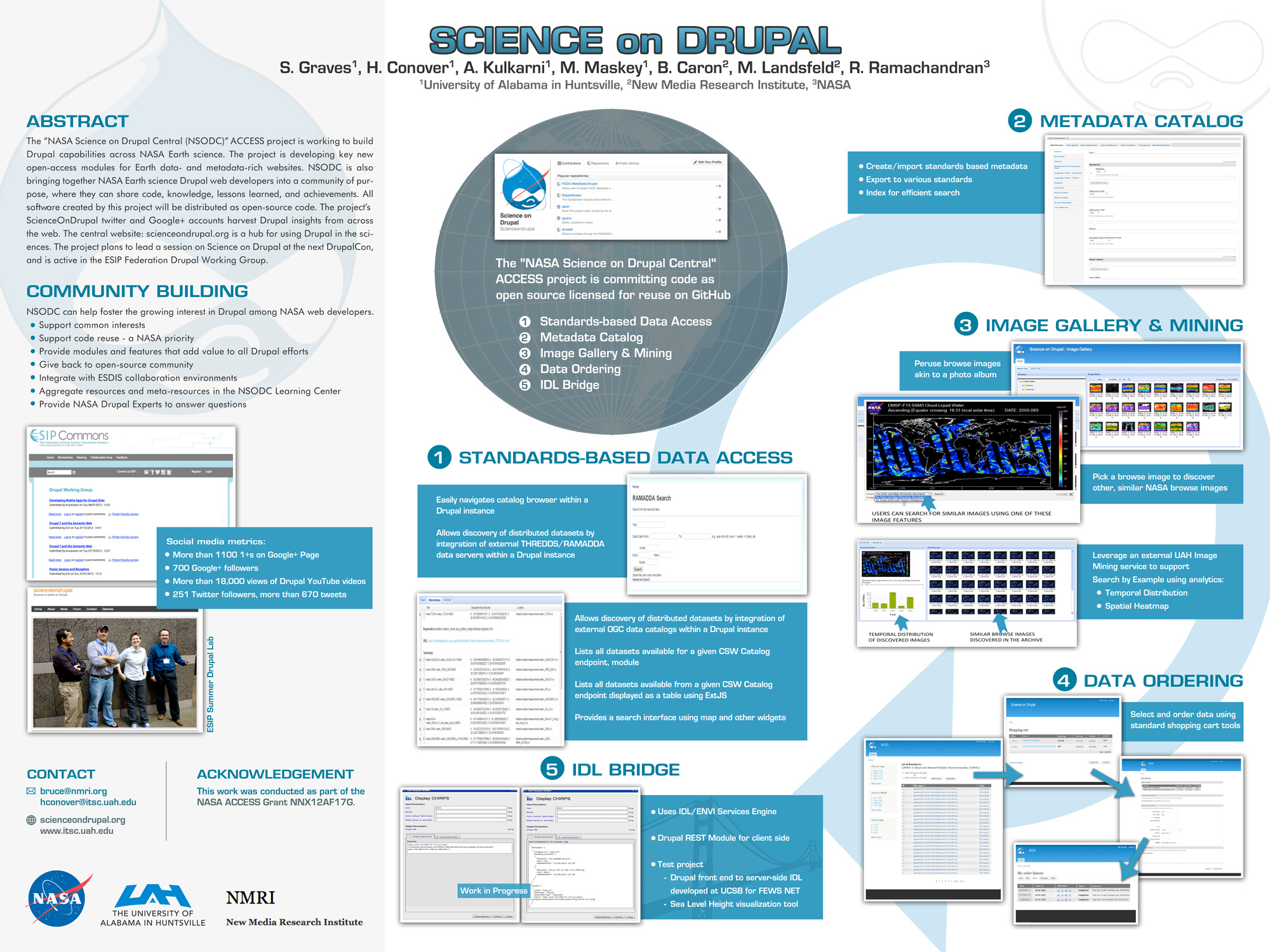
. Science on Drupal - ESIP. ESIP 2015 Winter Meeting [Internet]. 2015 . Available from: http://www.itsc.uah.edu/main/sites/default/files/sod_poster.jpg
. Science on Drupal - ESIP. ESIP 2015 Winter Meeting [Internet]. 2015 . Available from: http://www.itsc.uah.edu/main/sites/default/files/sod_poster.jpg
. SCOOP Data Management: A Standards-based Distributed Information System for Coastal Data Management. In: Standards-Based Data and Information Systems for Earth Observation. Standards-Based Data and Information Systems for Earth Observation. Springer-Verlag; 2010. pp. 93-111. Available from: http://www.springerlink.com/content/h72m155753p3m2g6/
. SCOOP Data Management: A Standards-based Distributed System for Coastal Data and Modeling. IEEE International Geoscience & Remote Sensing Symposium (IGARSS '06). 2006 ;1:317-320.
. Security Tag Computation and Propagation in OSFA. In: SPIE Defense + Security Conference. SPIE Defense + Security Conference. Orlando, FL: SPIE Defense + Security Conference; 2018.
. Semanitcs and Earth Science Markup Language. Earth Science Technology Conference. 2003 .
. The Sensor Management for Applied Research Technologies (SMART) Project. NASA Science Technology Conference [Internet]. 2007 . Available from: http://esto.nasa.gov/conferences/nstc2007/papers/Goodman_Michael__A1P1_NSTC-07-0120.pdf
. Service Oriented Architecture for Data Mining at Data Centers and Computing Centers. Cloud Computing and Collaborative Technologies in Geosciences. 2009 .
