PUBLICATIONS and PRESENTATIONS
. Highly weathered mineralogy of select soils from Southeastern U.S. Coastal Plain and Piedmont landscapes . Geoderma [Internet]. 2010 ;154(3-4):447-456. Available from: http://www.sciencedirect.com/science/article/pii/S0016706109000305
. Introducing LANCE, NASA’s Near-real-time Processing Capability for Aqua AMSR-E. In: American Geophysical Union. American Geophysical Union. San Francisco, CA; 2010.
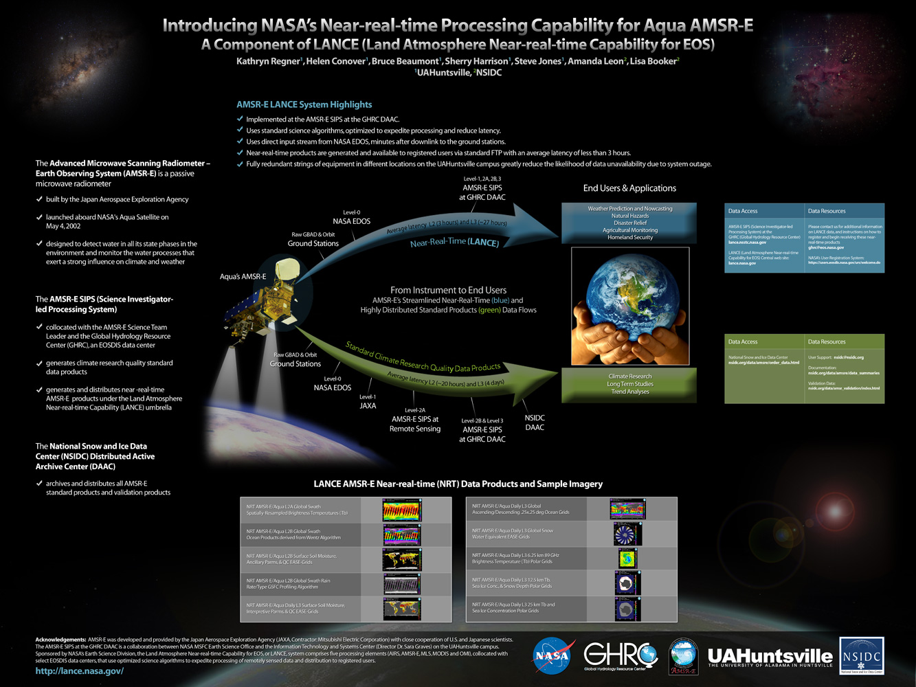
. Introducing NASA's Near-real-time Processing Capability for Aqua AMSR-E . [Internet]. 2010 . Available from: http://www.itsc.uah.edu/main/sites/default/files/lance_poster.jpg
. Introducing NASA's Near-real-time Processing Capability for Aqua AMSR-E . [Internet]. 2010 . Available from: http://www.itsc.uah.edu/main/sites/default/files/lance_poster.jpg
. SCOOP Data Management: A Standards-based Distributed Information System for Coastal Data Management. In: Standards-Based Data and Information Systems for Earth Observation. Standards-Based Data and Information Systems for Earth Observation. Springer-Verlag; 2010. pp. 93-111. Available from: http://www.springerlink.com/content/h72m155753p3m2g6/
. SCOOP Data Management: A Standards-based Distributed Information System for Coastal Data Management. In: Standards-Based Data and Information Systems for Earth Observation. Standards-Based Data and Information Systems for Earth Observation. Springer-Verlag; 2010. pp. 93-111. Available from: http://www.springerlink.com/content/h72m155753p3m2g6/
. SCOOP Data Management: A Standards-based Distributed Information System for Coastal Data Management. In: Standards-Based Data and Information Systems for Earth Observation. Standards-Based Data and Information Systems for Earth Observation. Springer-Verlag; 2010. pp. 93-111. Available from: http://www.springerlink.com/content/h72m155753p3m2g6/
. Using Sensor Web Protocols for Environmental Data Acquisition and Management. Ecological Informatics. 2010 ;5(1):32-41.
. Using Sensor Web Protocols for Environmental Data Acquisition and Management. Ecological Informatics. 2010 ;5(1):32-41.
. Visualizations for the Spyglass Ontology Based Information Analysis and Retrieval System. In: The 48th ACM Southeast Conference. The 48th ACM Southeast Conference. Oxford, MS; 2010.
. The Waypoint Planning Tool: Real Time Flight Planning for Airborne Science. In: American Geophysical Union. American Geophysical Union. San Francisco, CA; 2010.
. Coordinating Aircraft During NASA Airborne Science Field Campaigns. In: Earth Science Technology Forum. Earth Science Technology Forum. Pasadena, CA; 2011.
. GLIDER: Application for Earth Science Data Mining and Visualization. In: Rocket City Geospatial & Alabama GIS Conference. Rocket City Geospatial & Alabama GIS Conference. Huntsville, AL; 2011.
Instant Karma Status Update: Provenance at the AMSR-E SIPS. [Internet]. 2011 . Available from: https://www.itsc.uah.edu/sites/default/files/karma_poster.jpg
An Integrated Approach for Accessing Multiple Datasets through LANCE. 2011 Fall Meeting AGU. 2011 .
An Integrated Approach for Accessing Multiple Datasets through LANCE. 2011 Fall Meeting AGU. 2011 .
An Integrated Approach for Accessing Multiple Datasets through LANCE. 2011 Fall Meeting AGU. 2011 .
. New Tool for Satellite Image Analysis. 2011 ;92(11):1407.
. OOSTethys / Oceans IE Service Registry Based on Catalog Service for Web. In: Geospatial Web Services: Advances in Information Interoperability. Geospatial Web Services: Advances in Information Interoperability. IGI Global; 2011.
. Processing Direct Broadcast Data to Reduce Latency of Aqua AMSR-E Products. In: AGU. AGU. San Francisco, CA; 2011.
. Processing Direct Broadcast Data to Reduce Latency of Aqua AMSR-E Products. 2011 Fall Meeting AGU. 2011 .
. Provenance Collection and Display Tools for the AMSR-E SIPS. In: NASA Earth Science Data Systems Working Groups (ESDSWG) Meeting. NASA Earth Science Data Systems Working Groups (ESDSWG) Meeting. Newport News, VA; 2011.
The Use of LANCE Imagery Products to Investigate Hazards and Disasters. 2011 Fall Meeting AGU. 2011 .
The Use of LANCE Imagery Products to Investigate Hazards and Disasters. 2011 Fall Meeting AGU. 2011 .
