PUBLICATIONS and PRESENTATIONS
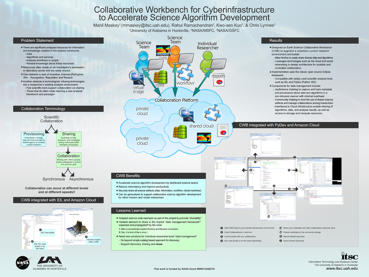
. Collaborative Workbench for Cyberinfrastructure to Accelerate Science Algorithm Development. ESIP 2014 Winter Meeting [Internet]. 2014 . Available from: http://www.itsc.uah.edu/main/sites/default/files/cwb_poster-sm.jpg
. Create Collaboratories for Earth Science using Talkoot. [Internet]. 2012 . Available from: https://www.itsc.uah.edu/sites/default/files/ESIPmeeting2012_Talkoot_poster.jpg
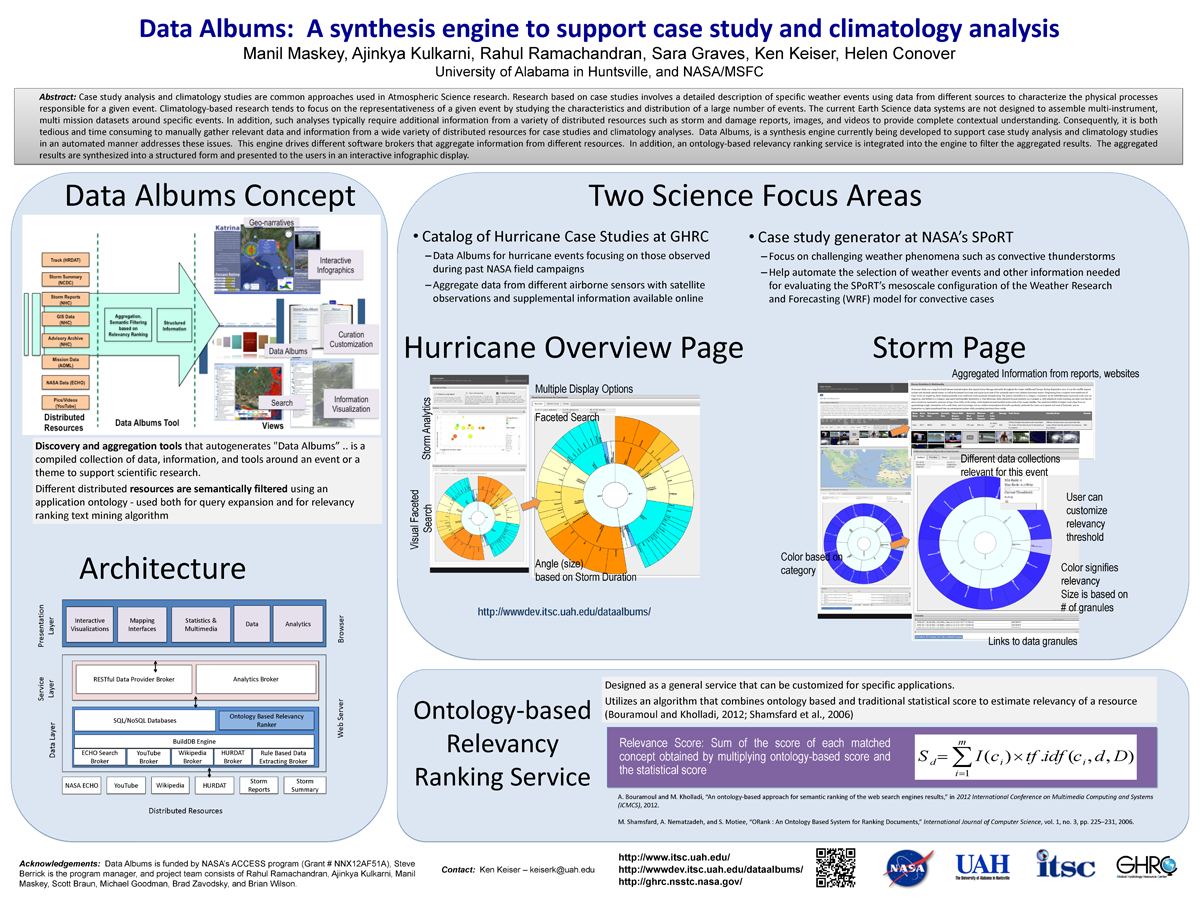
. Data Albums: A synthesis engine to support case study and climatology analysis (poster). ESIP 2014 Winter Meeting [Internet]. 2014 . Available from: http://www.itsc.uah.edu/main/sites/default/files/DataAlbums_ESIPWinter2014-v2_sm.png
. Data Systems for the HS3 Field Campaign. ESIP 2015 Winter Meeting [Internet]. 2015 . Available from: http://www.itsc.uah.edu/main/posters/data-system-hs3-field-campaign-agu-2014
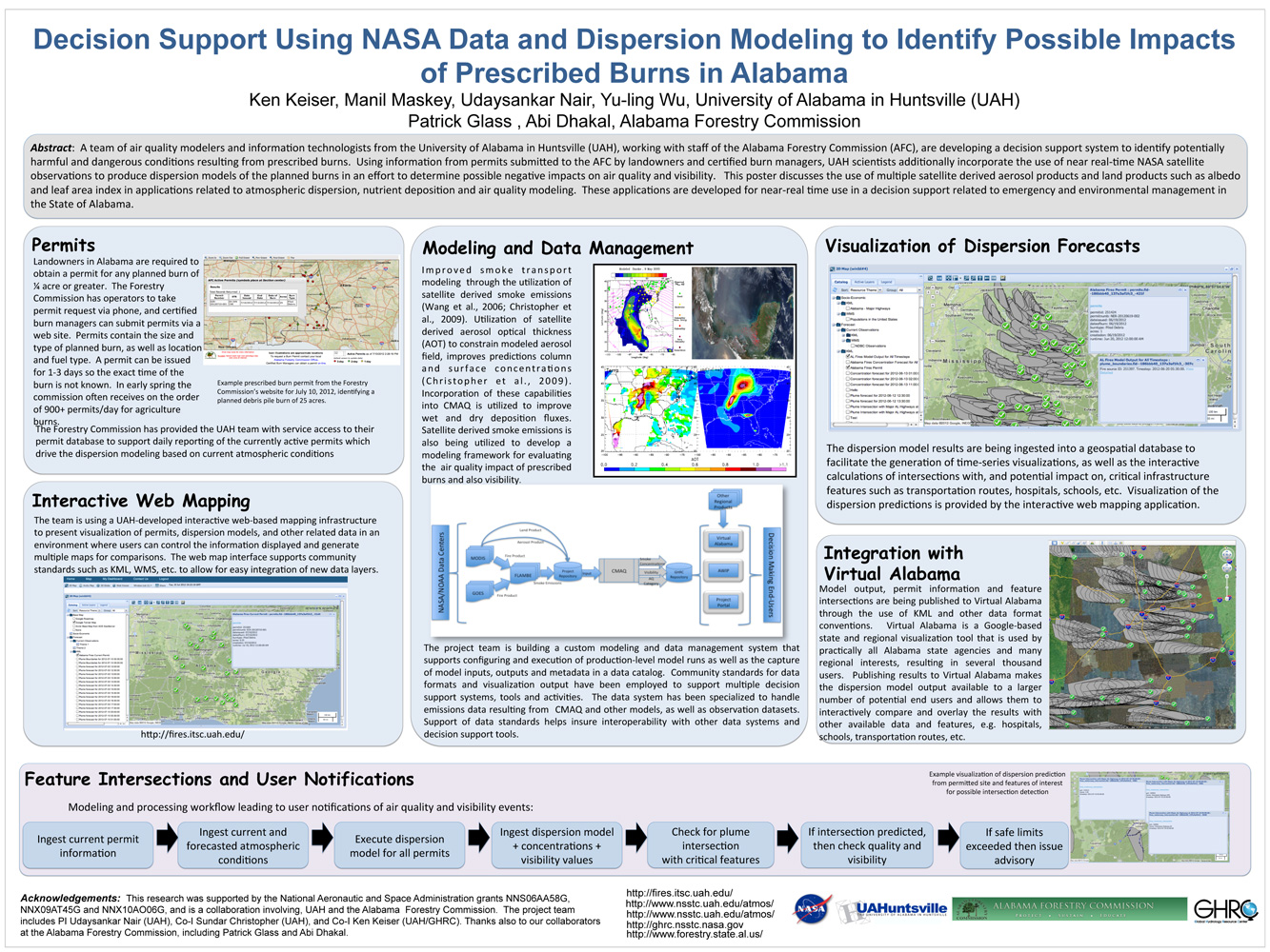
. Decision Support Using NASA Data and Dispersion Modeling to Identify Possible Impacts of Prescribed Burns in Alabama. ESIP Meeting 2012 [Internet]. 2012 . Available from: https://www.itsc.uah.edu/main/sites/default/files/Fires-for-ESIP-July-2012-v2.jpg
. Development of a Deep Learning Super-Resolution Generative Adversarial Network (SGAN) for Improving the Resolution of Global Precipitation Measurement (GPM) Dual-Frequency Precipitation Radar (DPR) Data. American Geophysical Union. 2019 .
. Disaster Event-Based Data Collections with ArcGIS Online Data Processing . Esri Annual User's Conference. 2017 .
. Dizzy the Disdrometer . AGU 2018. 2018 .
. EarthCube’s Evolving Science Workbench. EarthCube All Hands Meeting. 2018 .
. ECITE and Beyond . NSF EarthCube All Hands Meeting. 2017 .
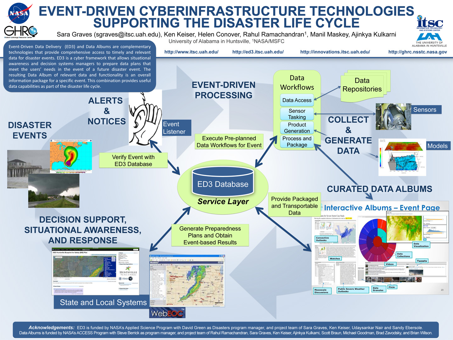
. Event-Driven Cyberinfrastructure Technologies Supporting the Disaster Lifecycle (at ESIP). ESIP 2015 Winter Meeting [Internet]. 2015 . Available from: http://www.itsc.uah.edu/main/sites/default/files/AGU-ED3-Eventdriven-poster.jpg
. Event-Driven Cyberinfrastructure Technologies Supporting the Disaster Lifecycle. AGU [Internet]. 2014 . Available from: http://www.itsc.uah.edu/main/sites/default/files/AGU-ED3-Eventdriven-poster.jpg
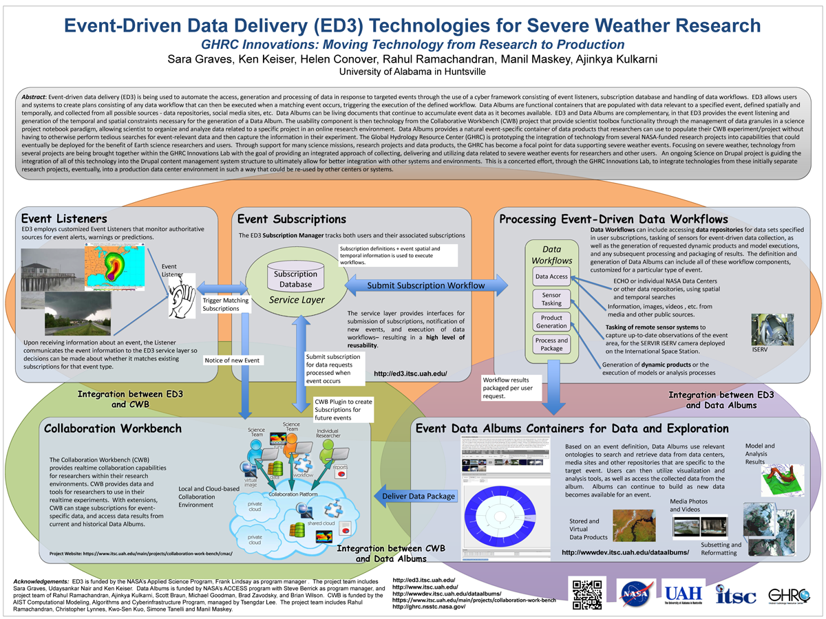
. Event-Driven Data Delivery (ED3) Technologies for Severe Weather Research, GHRC Innovations: Moving Technology from Research to Production. ESIP 2014 Winter Meeting [Internet]. 2014 . Available from: http://www.itsc.uah.edu/main/sites/default/files/ED3%2Bfor-ESIP-Jan-2014-v2_sm.png
. Evolving Frameworks for Different Communities of Scientists and End Users . American Geophysical Union 2016 Fall Meeting. 2016 .
. GLIDER: Earth Science Image Visualization and Analysis. 2010 [Internet]. 2010 . Available from: https://www.itsc.uah.edu/main/sites/default/files/glider_poster.jpg
. The Global Hydrology Resource Center Distributed Active Archive Center . 44th National Weather Association Annual Meeting. 2019 .
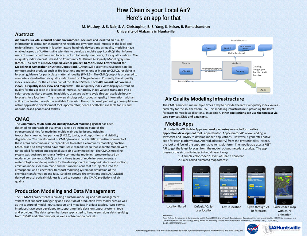
. How Clean is your Local Air? Here's an app for that. AGU 2011 [Internet]. 2011 . Available from: https://www.itsc.uah.edu/main/sites/default/files/agu2011_DEMAND-AQ-Poster.jpg
Instant Karma Status Update: Provenance at the AMSR-E SIPS. [Internet]. 2011 . Available from: https://www.itsc.uah.edu/sites/default/files/karma_poster.jpg
. Integrated Geospatial Distribution Systems for Disaster Event Data . Geological Society of America Southeastern Conference. 2017 .
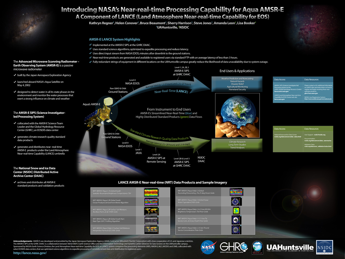
. Introducing NASA's Near-real-time Processing Capability for Aqua AMSR-E . [Internet]. 2010 . Available from: http://www.itsc.uah.edu/main/sites/default/files/lance_poster.jpg
. Land, Atmosphere Near Real-time Capability for EOS (LANCE) AMSR2 Data System. American Geophysical Union 2016 Fall Meeting. 2016 .
. Lightning Imaging Sensor (LIS) on the International Space Station (ISS) Activation, Assessment and Operation in the First Six Months . International Space Station Research & Development (ISS&RD). 2017 .
. Making connections: Where STEM learning and Earth science data services meet. American Geophysical Union 2016 Fall Meeting. 2016 .
. Meet Dizzy the Distometer: Creating a character and telling his story using ESRI Story Maps to increase use of Global Precipitation Measurement Ground Validation precipitation data . AMS 2019. 2019 .
. A Metadata Catalog for the Northern Gulf Coastal Hazards Collaboratory. [Internet]. 2012 . Available from: https://www.itsc.uah.edu/sites/default/files/2011_coastalhazards_poster.jpg
