PUBLICATIONS and PRESENTATIONS
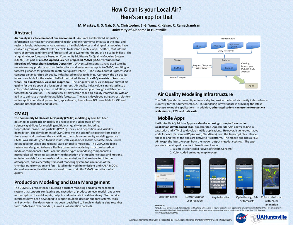
. How Clean is your Local Air? Here's an app for that. AGU 2011 [Internet]. 2011 . Available from: https://www.itsc.uah.edu/main/sites/default/files/agu2011_DEMAND-AQ-Poster.jpg
Instant Karma Status Update: Provenance at the AMSR-E SIPS. [Internet]. 2011 . Available from: https://www.itsc.uah.edu/sites/default/files/karma_poster.jpg
. Key Provenance of Earth Science Observational Data Products. American Geophysical Union. 2011 .
. OOSTethys / Oceans IE Service Registry Based on Catalog Service for Web. In: Geospatial Web Services: Advances in Information Interoperability. Geospatial Web Services: Advances in Information Interoperability. IGI Global; 2011.
. Processing Direct Broadcast Data to Reduce Latency of Aqua AMSR-E Products. 2011 Fall Meeting AGU. 2011 .
. Processing Direct Broadcast Data to Reduce Latency of Aqua AMSR-E Products. In: AGU. AGU. San Francisco, CA; 2011.
. Provenance Collection and Display Tools for the AMSR-E SIPS. In: NASA Earth Science Data Systems Working Groups (ESDSWG) Meeting. NASA Earth Science Data Systems Working Groups (ESDSWG) Meeting. Newport News, VA; 2011.
. Applying the Karma Provenance tool to NASA’s AMSR-E data production stream. In: American Geophysical Union. American Geophysical Union. San Francisco, CA; 2010.
. Collaboration Tools and Technologies for Scientific Field Campaigns. In: Internet2. Internet2. Atlanta, GA; 2010.
. Collaboration Tools and Technologies for Scientific Field Campaigns. In: Internet2. Internet2. Atlanta, GA; 2010.
. A Data and Information System for Arctic Research. In: American Geophysical Union. American Geophysical Union. ; 2010.
. Evaluation of Data Reduction Algorithms for Real-time assimilation and analysis. Weather Analysis and Forecasting [Internet]. 2010 . Available from: http://journals.ametsoc.org/doi/abs/10.1175/2010WAF2222296.1
. GLIDER: Earth Science Image Visualization and Analysis. 2010 [Internet]. 2010 . Available from: https://www.itsc.uah.edu/main/sites/default/files/glider_poster.jpg
. Global Hydrology Resource Center: A Foundation for Research Using Earth Observation Data. In: 61st International Astronautical Congress. 61st International Astronautical Congress. Prague, Czech Republic; 2010.
. GRIP Collaboration Portal: Information Management for a Hurricane Field Campaign. In: American Geophysical Union. American Geophysical Union. ; 2010.
. GRIP Collaboration Portal: Information Management for a Hurricane Field Campaign. In: American Geophysical Union. American Geophysical Union. ; 2010.
. Introducing LANCE, NASA’s Near-real-time Processing Capability for Aqua AMSR-E. In: American Geophysical Union. American Geophysical Union. San Francisco, CA; 2010.
. SCOOP Data Management: A Standards-based Distributed Information System for Coastal Data Management. In: Standards-Based Data and Information Systems for Earth Observation. Standards-Based Data and Information Systems for Earth Observation. Springer-Verlag; 2010. pp. 93-111. Available from: http://www.springerlink.com/content/h72m155753p3m2g6/
. Using Sensor Web Protocols for Environmental Data Acquisition and Management. Ecological Informatics. 2010 ;5(1):32-41.
. Visualizations for the Spyglass Ontology Based Information Analysis and Retrieval System. In: The 48th ACM Southeast Conference. The 48th ACM Southeast Conference. Oxford, MS; 2010.
. Visualize, analyze and mine satellite imagery using GLIDER software tool. In: 90th AMS Annual Meeting. 90th AMS Annual Meeting. Atlanta, GA; 2010.
. The Waypoint Planning Tool: Real Time Flight Planning for Airborne Science. In: American Geophysical Union. American Geophysical Union. San Francisco, CA; 2010.
The 2nd Generation Real Time Mission Monitor (RTMM) Development. In: American Geophysical Union. American Geophysical Union. San Francisco, CA; 2009. Available from: http://adsabs.harvard.edu/abs/2009AGUFMIN33A1026B
The 2nd Generation Real Time Mission Monitor (RTMM) Development. In: American Geophysical Union. American Geophysical Union. San Francisco, CA; 2009. Available from: http://adsabs.harvard.edu/abs/2009AGUFMIN33A1026B
. Considerations for Semantic e-Science. In: American Geophysical Union. American Geophysical Union. San Francisco, CA; 2009. Available from: http://adsabs.harvard.edu/abs/2009AGUFMIN51B1043G
