PUBLICATIONS and PRESENTATIONS
. ECITE and Beyond . NSF EarthCube All Hands Meeting. 2017 .
. Science-Driven Workbench . NSF EarthCube All Hands Meeting. 2017 .
. ECITE: A Testbed for Assessment of Technology Interoperability and Integration with Architecture Components . American Geophysical Union 2016 Fall Meeting. 2016 .
. Evolving Frameworks for Different Communities of Scientists and End Users . American Geophysical Union 2016 Fall Meeting. 2016 .
. Applying Advanced
Technologies for
GeoInt Solutions. Geo-Energy Summit. 2014 .
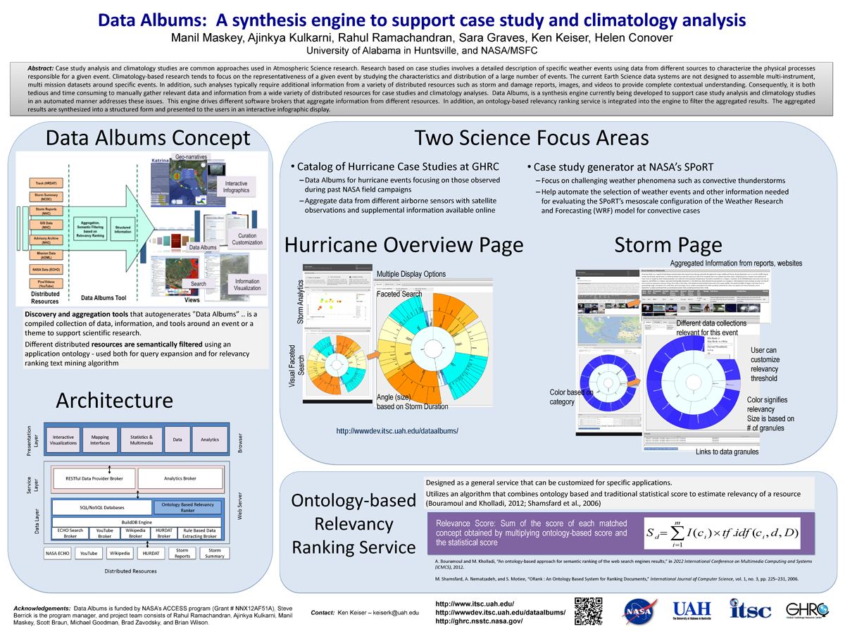
. Data Albums: A synthesis engine to support case study and climatology analysis (poster). ESIP 2014 Winter Meeting [Internet]. 2014 . Available from: http://www.itsc.uah.edu/main/sites/default/files/DataAlbums_ESIPWinter2014-v2_sm.png
. Event-based Technologies. GeoHSV/GeoInt TechVet2. 2014 .
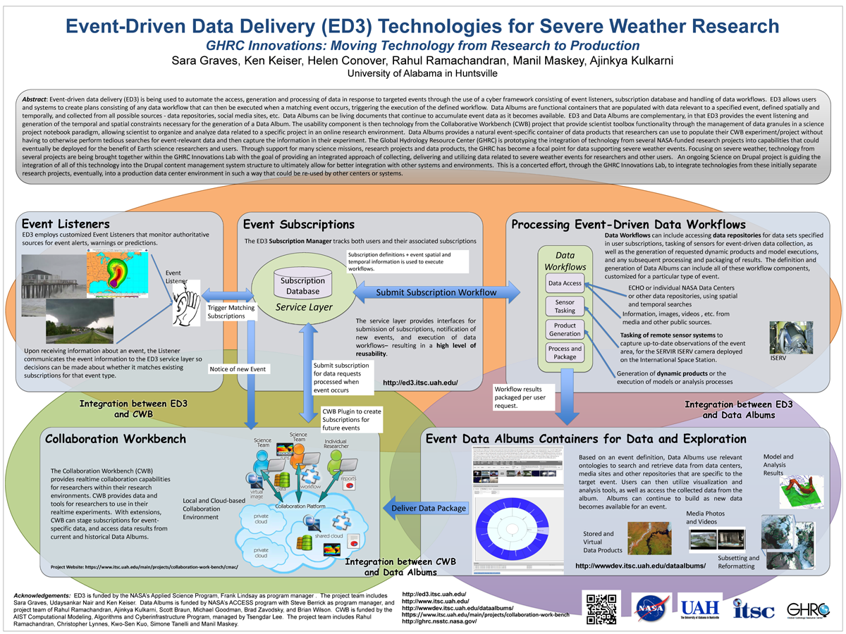
. Event-Driven Data Delivery (ED3) Technologies for Severe Weather Research, GHRC Innovations: Moving Technology from Research to Production. ESIP 2014 Winter Meeting [Internet]. 2014 . Available from: http://www.itsc.uah.edu/main/sites/default/files/ED3%2Bfor-ESIP-Jan-2014-v2_sm.png
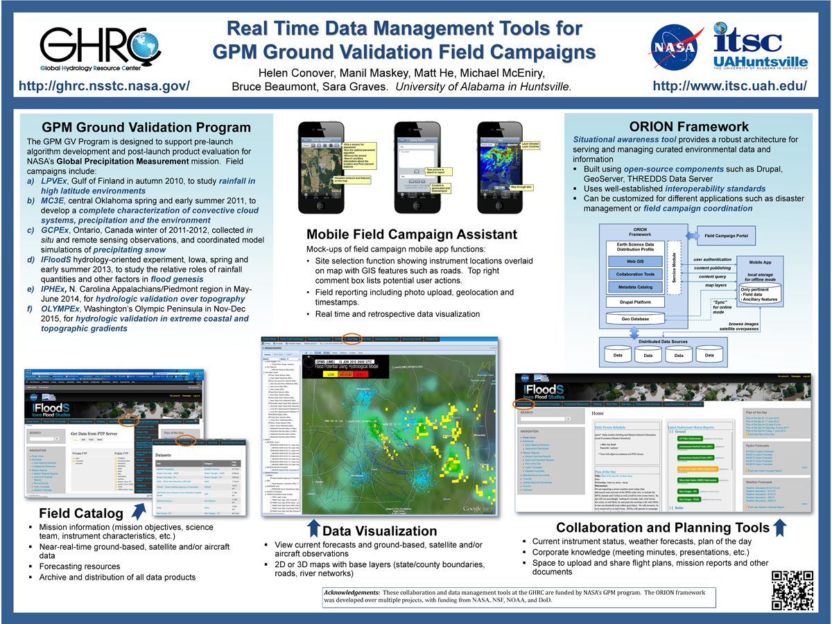
. Real Time Data Management Tools for GPM Ground Validation Field Campaigns. ESIP 2014 Winter Meeting [Internet]. 2014 . Available from: http://www.itsc.uah.edu/main/sites/default/files/GPMGV-Poster-ESIP-2014-01_sm.png
. Data Prospecting–A Step Towards Data Intensive Science. IEEE Journal of Selected Topics in Applied Earth Observations and Remote Sensing. 2013 ;6(3):1233-1241.
. Expanding the Role of an Earth Science Data System: The GHRC Innovations Lab. In: AGU. AGU. San Francisco, CA: AGU; 2013.
. Introducing Provenance Capture into a Legacy Data System. IEEE Transactions on Geoscience and Remote Sensing. 2013 ;51(11).
. ISO Lineage Metadata at the AMSR-E SIPS. ESIP Federation Winter Meeting 2013 [Internet]. 2013 . Available from: http://commons.esipfed.org/node/1037
. Provenance as a Guide to Understanding Science Data. IEEE International Geoscience and Remote Sensing Symposium. 2013 .
. Collaborative Research: The Northern Gulf Coastal Hazards Collaboratory. [Internet]. 2012 . Available from: https://www.itsc.uah.edu/sites/default/files/2011_coastalhazards_poster.jpg
. GLIDER: A Platform for Remote Sensing Data Visualization/Fusion/Analysis. In: Hyperspectral & Polarimetric Community Collaboration Workshop. Hyperspectral & Polarimetric Community Collaboration Workshop. Huntsville, AL; 2012. Available from: http://smapcenter.uah.edu/SMAP-CENTER/Conferences/HyperPolar2012/index.html
. A Large Scale Sensor Network Simulation for Aircraft/Missile Detection/Tracking. In: Hyperspectral & Polarimetric Community Collaboration Workshop. Hyperspectral & Polarimetric Community Collaboration Workshop. Huntsville, AL; 2012. Available from: http://smapcenter.uah.edu/SMAP-CENTER/Conferences/HyperPolar2012/index.html
. A Metadata Catalog for the Northern Gulf Coastal Hazards Collaboratory. [Internet]. 2012 . Available from: https://www.itsc.uah.edu/sites/default/files/2011_coastalhazards_poster.jpg
. A Metadata Catalog for the Northern Gulf Coastal Hazards Collaboratory. Northern Gulf Coastal Hazards Collaboratory Annual Meeting. 2012 .
. Mine Your Data: GLIDER brings data mining to the masses. [Internet]. 2012 . Available from: https://www.itsc.uah.edu/sites/default/files/esipmeeting2011_glider.jpg
. Provenance Collection and Display for the AMSR-E SIPS. [Internet]. 2012 . Available from: https://www.itsc.uah.edu/sites/default/files/ESIPmeeting2012_ProvenancePoster_0.jpg
. Using Unclassified Multi-Spectral Data to Improve OPIR Analysis. In: Hyperspectral & Polarimetric Community Collaboration Workshop. Hyperspectral & Polarimetric Community Collaboration Workshop. Huntsville, AL; 2012. Available from: http://smapcenter.uah.edu/SMAP-CENTER/Conferences/HyperPolar2012/index.html
. A Collaborative Environment for the Northern Gulf Coastal Hazards Collaboratory. Northern Gulf Institute. 2011 .
. A Collaborative Multidisciplinary Environment for Coastal Science. American Geophysical Union Fall Meeting. 2011 .
. GLIDER: Application for Earth Science Data Mining and Visualization. In: Rocket City Geospatial & Alabama GIS Conference. Rocket City Geospatial & Alabama GIS Conference. Huntsville, AL; 2011.
